IMAGES TAKEN NEAR TO
The Crossroads, EYE, IP23 8AZ
Introduction
This page details the photographs taken nearby to The Crossroads, IP23 8AZ by members of the Geograph project.
The Geograph project started in 2005 with the aim of publishing, organising and preserving representative images for every square kilometre of Great Britain, Ireland and the Isle of Man.

There are currently over 7.5m images from over14,400 individuals and you can help contribute to the project by visiting https://www.geograph.org.uk
Image Map
Images are licensed for reuse under creativecommons.org/licenses/by-sa/2.0
Notes
- Clicking on the map will re-center to the selected point.
- The higher the marker number, the further away the image location is from the centre of the postcode.
Image Listing (47 Images Found)
Images are licensed for reuse under creativecommons.org/licenses/by-sa/2.0
Image
Details
Distance
1
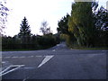
Rectory Road, Brome
At the junction with the B1077 Eye Road
Image: © Geographer
Taken: 28 Oct 2011
0.06 miles
2
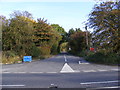
Rectory Road, Brome
At the junction with the B1077 Eye Road
Image: © Geographer
Taken: 28 Oct 2011
0.07 miles
3
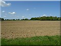
Field off Eye Road, Brome
Towards the A140.
Image: © JThomas
Taken: 16 May 2023
0.08 miles
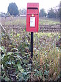
4
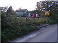
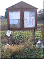
Brome Notice Board & The Common Postbox
Postbox No.IP23 7087
Image: © Geographer
Taken: 28 Oct 2011
0.08 miles
6
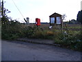
Brome Notice Board & The Common Postbox
Postbox No.IP23 7087
Image: © Geographer
Taken: 28 Oct 2011
0.09 miles
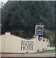
7

Sign on wall, Best Western Brome Grange Hotel
Image: © JThomas
Taken: 15 Sep 2015
0.09 miles
10
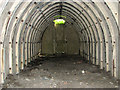
A Stanton air raid shelter
It is situated on the aerodrome's former Sick quarters site and dates from WW2, when RAF Eye was an active airfield.
Image: © Evelyn Simak
Taken: 6 Jun 2015
0.09 miles