IMAGES TAKEN NEAR TO
Castle Street, EYE, IP23 7AW
Introduction
This page details the photographs taken nearby to Castle Street, IP23 7AW by members of the Geograph project.
The Geograph project started in 2005 with the aim of publishing, organising and preserving representative images for every square kilometre of Great Britain, Ireland and the Isle of Man.

There are currently over 7.5m images from over14,400 individuals and you can help contribute to the project by visiting https://www.geograph.org.uk
Image Map
Images are licensed for reuse under creativecommons.org/licenses/by-sa/2.0
Notes
- Clicking on the map will re-center to the selected point.
- The higher the marker number, the further away the image location is from the centre of the postcode.
Image Listing (412 Images Found)
Images are licensed for reuse under creativecommons.org/licenses/by-sa/2.0
Image
Details
Distance
1
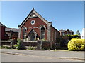
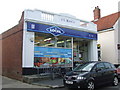
Gospel Centre, Eye
Off the B1117 Castle Street
Image: © Geographer
Taken: 30 Jun 2015
0.04 miles
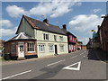
2
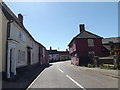
B1117 Castle Street, Eye
Near the Gospel Centre
Image: © Geographer
Taken: 30 Jun 2015
0.04 miles
3
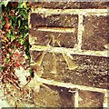
Cut Mark Eye Gospel Centre
Cut Mark Eye Gospel Centre NE face, E angle.
Image: © Cud05
Taken: 11 Aug 2017
0.05 miles
4
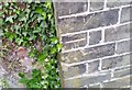
Ordnance Survey Cut Mark
This OS cut mark can be found on the Gospel Hall. It marks a point 34.6040m above mean sea level.
Image: © Adrian Dust
Taken: 2 May 2018
0.05 miles
6
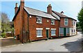
Buckshorn Lane, Eye
Housing in Buckshorn Lane.
Image: © Roger Jones
Taken: 17 Apr 2022
0.06 miles
7
Eye: House in Castle Hill seen from the steps leading up to the castle
Image: © Michael Garlick
Taken: 11 Sep 2020
0.06 miles
9
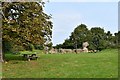
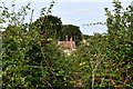
Eye Castle: All that remains of the curtain wall
Image: © Michael Garlick
Taken: 11 Sep 2020
0.06 miles
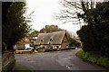
10
B1117 Castle Street, Eye
At the junction with the B1077 Lowgate Street
Image: © Geographer
Taken: 16 Jun 2015
0.06 miles