IMAGES TAKEN NEAR TO
Long Lane, DISS, IP22 5UQ
Introduction
This page details the photographs taken nearby to Long Lane, IP22 5UQ by members of the Geograph project.
The Geograph project started in 2005 with the aim of publishing, organising and preserving representative images for every square kilometre of Great Britain, Ireland and the Isle of Man.

There are currently over 7.5m images from over14,400 individuals and you can help contribute to the project by visiting https://www.geograph.org.uk
Image Map
Images are licensed for reuse under creativecommons.org/licenses/by-sa/2.0
Notes
- Clicking on the map will re-center to the selected point.
- The higher the marker number, the further away the image location is from the centre of the postcode.
Image Listing (22 Images Found)
Images are licensed for reuse under creativecommons.org/licenses/by-sa/2.0
Image
Details
Distance
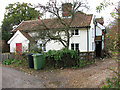
3
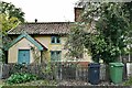
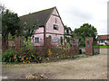
Burston and Shimpling: 'Elbow Cottage'
Image: © Michael Garlick
Taken: 10 Nov 2022
0.03 miles
4
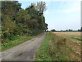
Footpath off Long Lane
Burston and Shimpling Footpath No.7
Image: © Geographer
Taken: 21 Sep 2016
0.03 miles
7
Public footpath to Manor House Farm, The Heywood
Image: © Evelyn Simak
Taken: 12 Nov 2010
0.09 miles
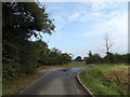
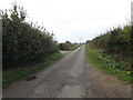
8
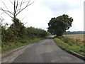
Long Lane, Burston
Near Gissing Water Tower
Road No.U76107
Image: © Geographer
Taken: 21 Sep 2016
0.09 miles
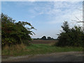
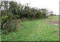
9
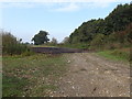
Hardstanding off Long Lane
Near Gissing Water Tower
Image: © Geographer
Taken: 21 Sep 2016
0.11 miles
10
Long Lane, Gissing
At the entrance to Gissing Water Tower
Image: © Geographer
Taken: 21 Sep 2016
0.11 miles