IMAGES TAKEN NEAR TO
Audley End, DISS, IP22 5TY
Introduction
This page details the photographs taken nearby to Audley End, IP22 5TY by members of the Geograph project.
The Geograph project started in 2005 with the aim of publishing, organising and preserving representative images for every square kilometre of Great Britain, Ireland and the Isle of Man.

There are currently over 7.5m images from over14,400 individuals and you can help contribute to the project by visiting https://www.geograph.org.uk
Image Map
Images are licensed for reuse under creativecommons.org/licenses/by-sa/2.0
Notes
- Clicking on the map will re-center to the selected point.
- The higher the marker number, the further away the image location is from the centre of the postcode.
Image Listing (25 Images Found)
Images are licensed for reuse under creativecommons.org/licenses/by-sa/2.0
Image
Details
Distance
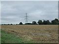
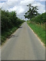
4
Audley End
Heading north west towards Burston.
Image: © JThomas
Taken: 15 Sep 2015
0.07 miles
5
Audley End
Audley End looking north near to Burston, Norfolk.
Image: © Keith Evans
Taken: 16 Aug 2012
0.07 miles
6
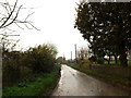
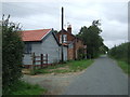
Audley End, Burston
Approaching Audley End Crossing
Road No.C341
Image: © Geographer
Taken: 22 Nov 2014
0.13 miles
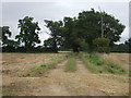
7
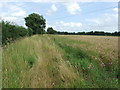
Footpath
Footpath looking east near to Burston, Norfolk.
Image: © Keith Evans
Taken: 16 Aug 2012
0.14 miles
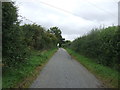
8
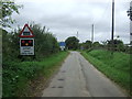
Approaching the level crossing on Audley End
Heading north west.
Image: © JThomas
Taken: 15 Sep 2015
0.16 miles
9
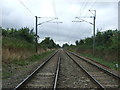
Railway towards Diss and London
Looking south west from the level crossing on Audley End.
Image: © JThomas
Taken: 15 Sep 2015
0.18 miles
10
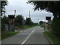
Level crossing on Audley End
The Norwich to London Railway.
Image: © JThomas
Taken: 15 Sep 2015
0.20 miles