IMAGES TAKEN NEAR TO
Bellrope Lane, DISS, IP22 5RG
Introduction
This page details the photographs taken nearby to Bellrope Lane, IP22 5RG by members of the Geograph project.
The Geograph project started in 2005 with the aim of publishing, organising and preserving representative images for every square kilometre of Great Britain, Ireland and the Isle of Man.

There are currently over 7.5m images from over14,400 individuals and you can help contribute to the project by visiting https://www.geograph.org.uk
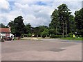
Image Map
Images are licensed for reuse under creativecommons.org/licenses/by-sa/2.0
Notes
- Clicking on the map will re-center to the selected point.
- The higher the marker number, the further away the image location is from the centre of the postcode.
Image Listing (121 Images Found)
Images are licensed for reuse under creativecommons.org/licenses/by-sa/2.0
Image
Details
Distance
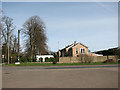
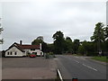
3
Bellrope Lane, Roydon
At the junction with the A1066 High Road
Image: © Geographer
Taken: 23 May 2015
0.06 miles
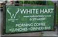
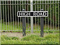
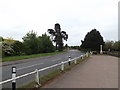
5
A1066 High Road & The White Hart Public House
At the junction with Bellrope Lane
Image: © Geographer
Taken: 23 May 2015
0.07 miles
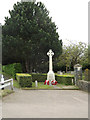
8

Roydon War Memorial
There are 19 names on the memorial for WW1 and 3 for WW2, which are: Victor Frederick Moss, Frances Lilian Brand and Rowland walter Lines.
Image: © Adrian S Pye
Taken: 15 Apr 2015
0.07 miles
9
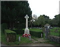
War Memorial, Roydon
On High Road, in front of church.
Image: © JThomas
Taken: 17 Sep 2015
0.07 miles
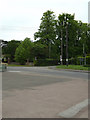
10
Roydon War Memorial
Off the A1066 High Road
Image: © Geographer
Taken: 23 May 2015
0.07 miles