IMAGES TAKEN NEAR TO
Thetford Road, DISS, IP22 2SU
Introduction
This page details the photographs taken nearby to Thetford Road, IP22 2SU by members of the Geograph project.
The Geograph project started in 2005 with the aim of publishing, organising and preserving representative images for every square kilometre of Great Britain, Ireland and the Isle of Man.

There are currently over 7.5m images from over14,400 individuals and you can help contribute to the project by visiting https://www.geograph.org.uk
Image Map
Images are licensed for reuse under creativecommons.org/licenses/by-sa/2.0
Notes
- Clicking on the map will re-center to the selected point.
- The higher the marker number, the further away the image location is from the centre of the postcode.
Image Listing (7 Images Found)
Images are licensed for reuse under creativecommons.org/licenses/by-sa/2.0
Image
Details
Distance
1
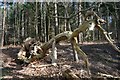
Home Covert
A fallen tree on the western fringe of Home Covert.
Image: © Bob Jones
Taken: 2 Mar 2007
0.16 miles
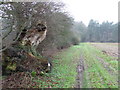
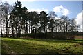
3
Edge Of Home Covert
The wood to the left is marked on O.S. maps as Home Covert looking west near to Garboldisham, Norfolk
Image: © Keith Evans
Taken: 24 Jan 2010
0.20 miles
4
Tree Stump
Tree stump and footpath near to Garboldisham, Norfolk.
Image: © Keith Evans
Taken: 23 Jan 2010
0.21 miles
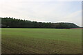
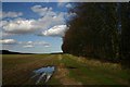
5
Footpath to Garboldisham Common
The wood on the right is Home Covert. The group of trees to the left hide a tumulus.
Image: © Bob Jones
Taken: 2 Mar 2007
0.21 miles
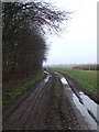
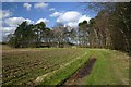
6
Footpath to Garboldisham Heath
Heading north with Home Covert to the right.
Image: © Bob Jones
Taken: 2 Mar 2007
0.23 miles
7
Tumulus at Garboldisham Common
The mound is almost hidden by the surrounding trees.
Image: © Bob Jones
Taken: 2 Mar 2007
0.23 miles