IMAGES TAKEN NEAR TO
Hopton Road, DISS, IP22 2RQ
Introduction
This page details the photographs taken nearby to Hopton Road, IP22 2RQ by members of the Geograph project.
The Geograph project started in 2005 with the aim of publishing, organising and preserving representative images for every square kilometre of Great Britain, Ireland and the Isle of Man.

There are currently over 7.5m images from over14,400 individuals and you can help contribute to the project by visiting https://www.geograph.org.uk
Image Map
Images are licensed for reuse under creativecommons.org/licenses/by-sa/2.0
Notes
- Clicking on the map will re-center to the selected point.
- The higher the marker number, the further away the image location is from the centre of the postcode.
Image Listing (45 Images Found)
Images are licensed for reuse under creativecommons.org/licenses/by-sa/2.0
Image
Details
Distance
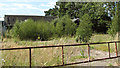
2
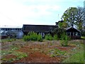
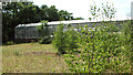
Disused greenhouses at derelict garden centre
Image: © Evelyn Simak
Taken: 10 Jul 2015
0.08 miles
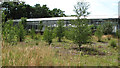
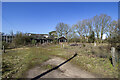
3
Disused greenhouses at derelict garden centre
Image: © Evelyn Simak
Taken: 10 Jul 2015
0.08 miles
6
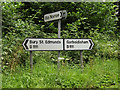
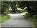
Roadsigns on the B1111 Common Road
At the junction with Hall Lane
Image: © Geographer
Taken: 12 Jul 2016
0.09 miles
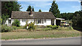
8
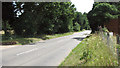
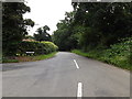
B1111 Common Road, Blo' Norton
At the junction with Hall Lane & B1111 Hopton Road
Image: © Geographer
Taken: 12 Jul 2016
0.09 miles
9
Hall Lane, Blo' Norton
At the junction with the B1111 Common Road & B1111 Hopton Road
Image: © Geographer
Taken: 12 Jul 2016
0.09 miles