IMAGES TAKEN NEAR TO
Mill Lane, DISS, IP22 2RG
Introduction
This page details the photographs taken nearby to Mill Lane, IP22 2RG by members of the Geograph project.
The Geograph project started in 2005 with the aim of publishing, organising and preserving representative images for every square kilometre of Great Britain, Ireland and the Isle of Man.

There are currently over 7.5m images from over14,400 individuals and you can help contribute to the project by visiting https://www.geograph.org.uk
Image Map
Images are licensed for reuse under creativecommons.org/licenses/by-sa/2.0
Notes
- Clicking on the map will re-center to the selected point.
- The higher the marker number, the further away the image location is from the centre of the postcode.
Image Listing (5 Images Found)
Images are licensed for reuse under creativecommons.org/licenses/by-sa/2.0
Image
Details
Distance
1
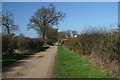
Mill Lane, Garboldisham Common
This track leads past farm buildings to Garboldisham Common and Hopton Fen.
Image: © Bob Jones
Taken: 2 Mar 2007
0.04 miles
2
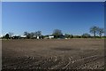
Farm buildings near Garboldisham
This farm and field are located north of Mill Lane, Garboldisham.
Image: © Bob Jones
Taken: 2 Mar 2007
0.06 miles
3
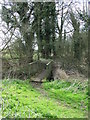
Footbridge
Footbridge Hopton Fen near to Hopton, Suffolk.
Image: © Keith Evans
Taken: 29 Mar 2009
0.19 miles
4
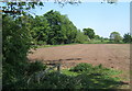
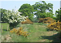
Field and track by the edge of Hopton Fen
Looking just across a grid line.
Image: © Andrew Hill
Taken: 13 May 2008
0.21 miles
5
Angles Way path near Hopton Fen, looking north
Image: © Andrew Hill
Taken: 13 May 2008
0.24 miles