IMAGES TAKEN NEAR TO
The Street, DISS, IP22 2LH
Introduction
This page details the photographs taken nearby to The Street, IP22 2LH by members of the Geograph project.
The Geograph project started in 2005 with the aim of publishing, organising and preserving representative images for every square kilometre of Great Britain, Ireland and the Isle of Man.

There are currently over 7.5m images from over14,400 individuals and you can help contribute to the project by visiting https://www.geograph.org.uk
Image Map
Images are licensed for reuse under creativecommons.org/licenses/by-sa/2.0
Notes
- Clicking on the map will re-center to the selected point.
- The higher the marker number, the further away the image location is from the centre of the postcode.
Image Listing (103 Images Found)
Images are licensed for reuse under creativecommons.org/licenses/by-sa/2.0
Image
Details
Distance
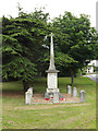
1
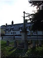
War Memorial
War memorial South Lopham, Norfolk.
Image: © Keith Evans
Taken: 31 Jan 2010
0.00 miles
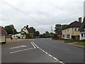
2
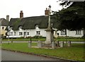
War Memorial and thatched cottages at South Lopham
Image: © Robert Edwards
Taken: 29 Oct 2010
0.01 miles
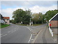
3
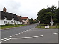
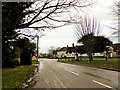
A1066 The Street, South Lopham
At the junction with Church Road
Image: © Geographer
Taken: 23 Jun 2015
0.02 miles
5
Road for North Lopham to the right off the A1066
Image: © Peter Robinson
Taken: 10 Oct 2011
0.02 miles
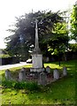
6
South Lopham War Memorial
On Church Road at the junction with the A1066 The Street
Image: © Geographer
Taken: 23 Jun 2015
0.02 miles
7
A1066 The Street, South Lopham
At the junction with Church Road
Image: © Geographer
Taken: 23 Jun 2015
0.02 miles
8
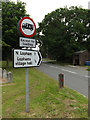
Roadsigns on Church Road
At the junction with the A1066 The Street
Image: © Geographer
Taken: 23 Jun 2015
0.03 miles
9
Bus shelter and War Memorial in South Lopham
...just before joining the A1066 eastbound.
Image: © Adrian S Pye
Taken: 25 Jan 2011
0.03 miles
10
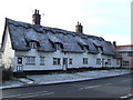
Cottages
Cottages The Street South Lopham, Norfolk.
Image: © Keith Evans
Taken: 31 Jan 2010
0.03 miles