1
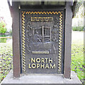
North Lopham Village Notice Board on The Green
Off The Street at the junction with Tanns Lane
Image: © Geographer
Taken: 16 Jul 2016
0.05 miles
2
North Lopham village sign
The five figures in the gold squares replicate the stones in the stringcourse found at the base of the church tower. The crowned “T” is for St. Thomas Becket, The “M” is for St. Mary and the “A” for St. Anthony the earlier dedication of the church. The man at the loom is weaving hempen cloth which was a major industry until it declined and finally ended in 1910. The spinning wheel represents another money earner for the women of the household. The object on the right was a peculiarity of North Lopham, it is a doorway on the outside of a chimney breast which was at Grange Farm until it was unfortunately demolished. Floral decoration include hemp, poppies and sweet chestnuts. The letters in gold are again from the south face of the church tower "ORATE P.AIA JOH KALLI" which in English is "Pray for the Soul of John Caley." A benefactor of the church. https://www.geograph.org.uk/photo/6686440
Image: © Adrian S Pye
Taken: 22 Nov 2020
0.06 miles
3
North Lopham village sign
The five figures in the gold squares replicate the stones in the stringcourse found at the base of the church tower. The crowned “T” is for St. Thomas Becket, The “M” is for St. Mary and the “A” for St. Anthony the earlier dedication of the church. The man at the loom is weaving hempen cloth which was a major industry until it declined and finally ended in 1910. The spinning wheel represents another money earner for the women of the household. The object on the right was a peculiarity of North Lopham, it is a doorway on the outside of a chimney breast which was at Grange Farm until it was unfortunately demolished. Floral decoration include hemp, poppies and sweet chestnuts. The letters in gold are again from the south face of the church tower "ORATE P.AIA JOH KALLI" which in English is "Pray for the Soul of John Caley." A benefactor of the church.
https://www.geograph.org.uk/photo/6686444
Image: © Adrian S Pye
Taken: 22 Nov 2020
0.06 miles
4
North Lopham Village sign on The Green
Off The Street at the junction with Tanns Lane
Image: © Geographer
Taken: 16 Jul 2016
0.06 miles
5
North Lopham Village sign on The Green
Off The Street at the junction with Tanns Lane
(Close up)
Image: © Geographer
Taken: 16 Jul 2016
0.06 miles
6
North Lopham Village sign on The Green
Off The Street at the junction with Tanns Lane
Image: © Geographer
Taken: 16 Jul 2016
0.06 miles
7
The Street, North Lopham
At the junction with Kings Head Lane
Image: © Geographer
Taken: 16 Jul 2016
0.08 miles
8
The Street, North Lopham
At the junction with Kings Head Lane
Image: © Geographer
Taken: 16 Jul 2016
0.08 miles
9
The Street, North Lopham
At the junction with kings Head Lane
Image: © Geographer
Taken: 16 Jul 2016
0.08 miles
10
Kings Head Lane, North Lopham
At the junction with The Street
Image: © Geographer
Taken: 16 Jul 2016
0.08 miles


