IMAGES TAKEN NEAR TO
Church Walk, DISS, IP22 2DU
Introduction
This page details the photographs taken nearby to Church Walk, IP22 2DU by members of the Geograph project.
The Geograph project started in 2005 with the aim of publishing, organising and preserving representative images for every square kilometre of Great Britain, Ireland and the Isle of Man.

There are currently over 7.5m images from over14,400 individuals and you can help contribute to the project by visiting https://www.geograph.org.uk
Image Map
Images are licensed for reuse under creativecommons.org/licenses/by-sa/2.0
Notes
- Clicking on the map will re-center to the selected point.
- The higher the marker number, the further away the image location is from the centre of the postcode.
Image Listing (167 Images Found)
Images are licensed for reuse under creativecommons.org/licenses/by-sa/2.0
Image
Details
Distance
1
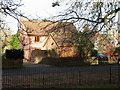
House opposite All Saints church
For a view of the church see > http://www.geograph.org.uk/photo/1572147.
Image: © Evelyn Simak
Taken: 7 Nov 2009
0.01 miles
2
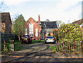
The Old Chapel
This converted Methodist chapel is situated just north-east of All Saints church > http://www.geograph.org.uk/photo/1572147.
Image: © Evelyn Simak
Taken: 7 Nov 2009
0.01 miles
3
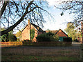
House north of All Saints church
For a view of the church see > http://www.geograph.org.uk/photo/1572147.
Image: © Evelyn Simak
Taken: 7 Nov 2009
0.01 miles
4
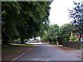
Church Walk, Shelfanger
Looking towards the B1077 Church Road near All Saints Church
Image: © Geographer
Taken: 20 Aug 2013
0.02 miles
5
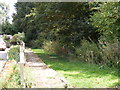
Footpath to Rectory Road
Off Church Walk near All Saints Church
Image: © Geographer
Taken: 20 Aug 2013
0.03 miles
6
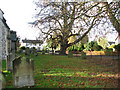
All Saints church - churchyard
For a view of the church see > http://www.geograph.org.uk/photo/1572147.
Image: © Evelyn Simak
Taken: 7 Nov 2009
0.03 miles
7
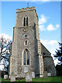
All Saints church
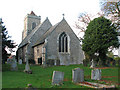
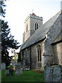
All Saints church > http://www.geograph.org.uk/photo/1572147 - http://www.geograph.org.uk/photo/1572170 stands beside the B 1077 (Church Road), the main thoroughfare through the village of Shelfanger. The tower has a square chequerwork decoration created by alternating white limestone and flint and it is topped by a red tiled pyramidal roof . Interestingly, the tower is slightly off-centre and not entirely square to the nave walls. The C16 north porch > http://www.geograph.org.uk/photo/1572168 still has the original timber framing with black flint and mortar infill. The oldest feature of the building is a wall painting > http://www.geograph.org.uk/photo/1572177 in the south-eastern corner of the chancel, which was discovered in 1966. The mural has been dated to the mid 13th century. The C14 octagonal font > http://www.geograph.org.uk/photo/1572181 was given by Adam Bosville whose initials are carved into the bowl. The stained glass windows > http://www.geograph.org.uk/photo/1572173 date from the time when the church was intensively restored (1876-1897) and were made by Clayton & Bell. All Saints church is open every day.
Image: © Evelyn Simak
Taken: 7 Nov 2009
0.03 miles
8
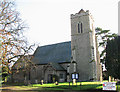
All Saints church
All Saints church > http://www.geograph.org.uk/photo/1572170 stands beside the B 1077 (Church Road), the main thoroughfare through the village of Shelfanger. The tower has a square chequerwork decoration created by alternating white limestone and flint and it is topped by a red tiled pyramidal roof . Interestingly, the tower is slightly off-centre > http://www.geograph.org.uk/photo/1572157 and not entirely square to the nave walls. The C16 north porch > http://www.geograph.org.uk/photo/1572168 still has the original timber framing with black flint and mortar infill. The oldest feature of the building is a wall painting > http://www.geograph.org.uk/photo/1572177 in the south-eastern corner of the chancel, which was discovered in 1966. The mural has been dated to the mid 13th century. The C14 octagonal font > http://www.geograph.org.uk/photo/1572181 was given by Adam Bosville whose initials are carved into the bowl. The stained glass windows > http://www.geograph.org.uk/photo/1572173 date from the time when the church was intensively restored (1876-1897) and were made by Clayton & Bell. All Saints church is open every day.
Image: © Evelyn Simak
Taken: 7 Nov 2009
0.04 miles
9
All Saints church
All Saints church > http://www.geograph.org.uk/photo/1572147 - http://www.geograph.org.uk/photo/1572170 stands beside the B 1077 (Church Road), the main thoroughfare through the village of Shelfanger. The tower has a square chequerwork decoration created by alternating white limestone and flint and it is topped by a red tiled pyramidal roof . Interestingly, the tower is slightly off-centre > http://www.geograph.org.uk/photo/1572157 and not entirely square to the nave walls. The C16 north porch > http://www.geograph.org.uk/photo/1572168 still has the original timber framing with black flint and mortar infill. The oldest feature of the building is a wall painting > http://www.geograph.org.uk/photo/1572177 in the south-eastern corner of the chancel, which was discovered in 1966. The mural has been dated to the mid 13th century. The C14 octagonal font > http://www.geograph.org.uk/photo/1572181 was given by Adam Bosville whose initials are carved into the bowl. The stained glass windows > http://www.geograph.org.uk/photo/1572173 date from the time when the church was intensively restored (1876-1897) and were made by Clayton & Bell. All Saints church is open every day.
Image: © Evelyn Simak
Taken: 7 Nov 2009
0.04 miles
10
All Saints church - churchyard
This is the southern section of All Saints' churchyard. All Saints church > http://www.geograph.org.uk/photo/1572147 - http://www.geograph.org.uk/photo/1572170 stands beside the B 1077 (Church Road), the main thoroughfare through the village of Shelfanger. The tower has a square chequerwork decoration created by alternating white limestone and flint and it is topped by a red tiled pyramidal roof . Interestingly, the tower is slightly off-centre > http://www.geograph.org.uk/photo/1572157 and not entirely square to the nave walls. The C16 north porch > http://www.geograph.org.uk/photo/1572168 still has the original timber framing with black flint and mortar infill. The oldest feature of the building is a wall painting > http://www.geograph.org.uk/photo/1572177 in the south-eastern corner of the chancel, which was discovered in 1966. The mural has been dated to the mid 13th century. The C14 octagonal font > http://www.geograph.org.uk/photo/1572181 was given by Adam Bosville whose initials are carved into the bowl. The stained glass windows > http://www.geograph.org.uk/photo/1572173 date from the time when the church was intensively restored (1876-1897) and were made by Clayton & Bell. All Saints church is open every day.
Image: © Evelyn Simak
Taken: 7 Nov 2009
0.04 miles