IMAGES TAKEN NEAR TO
Church Road, DISS, IP22 2DG
Introduction
This page details the photographs taken nearby to Church Road, IP22 2DG by members of the Geograph project.
The Geograph project started in 2005 with the aim of publishing, organising and preserving representative images for every square kilometre of Great Britain, Ireland and the Isle of Man.

There are currently over 7.5m images from over14,400 individuals and you can help contribute to the project by visiting https://www.geograph.org.uk
Image Map
Images are licensed for reuse under creativecommons.org/licenses/by-sa/2.0
Notes
- Clicking on the map will re-center to the selected point.
- The higher the marker number, the further away the image location is from the centre of the postcode.
Image Listing (169 Images Found)
Images are licensed for reuse under creativecommons.org/licenses/by-sa/2.0
Image
Details
Distance
1
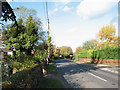
View north along the B1077 (Church Road)
The B1077 is the main thoroughfare through the village of Shelfanger.
Image: © Evelyn Simak
Taken: 7 Nov 2009
0.01 miles
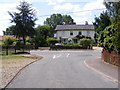
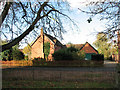
2
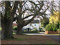
House on the B1077 (Church Road)
The B1077 is the main thoroughfare through the village of Shelfanger.
Image: © Evelyn Simak
Taken: 7 Nov 2009
0.03 miles
3
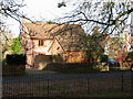
House opposite All Saints church
For a view of the church see > http://www.geograph.org.uk/photo/1572147.
Image: © Evelyn Simak
Taken: 7 Nov 2009
0.03 miles
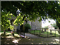
4
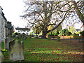
All Saints church - churchyard
For a view of the church see > http://www.geograph.org.uk/photo/1572147.
Image: © Evelyn Simak
Taken: 7 Nov 2009
0.03 miles
5
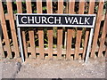
Church Walk sign
On Church Walk at the junction with the B1077 Church Road
Image: © Geographer
Taken: 20 Aug 2013
0.04 miles
6
Entrance to All Saints Church, Selfanger
Off Church Walk at the junction with the B1077 Church Road
http://www.norfolkchurches.co.uk/shelfanger/shelfanger.htm
Image: © Geographer
Taken: 20 Aug 2013
0.04 miles
7
Church Walk, Shelfanger
At the junction with the B1077 Church Road
Image: © Geographer
Taken: 20 Aug 2013
0.04 miles
8
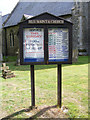
All Saints Church Notice Board
Off Church Walk at the junction with the B1077 Church Road
http://www.norfolkchurches.co.uk/shelfanger/shelfanger.htm
Image: © Geographer
Taken: 20 Aug 2013
0.04 miles
9
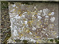
Ordnance Survey Cut Mark
This mark can be found on the wall of All Saints Church, Shelfanger. The benchmark height is recorded as being 38.53 metres above sea level.
For more detail see : https://www.bench-marks.org.uk/bm61234
Image: © Peter Wood
Taken: 22 Feb 2020
0.04 miles
10
House north of All Saints church
For a view of the church see > http://www.geograph.org.uk/photo/1572147.
Image: © Evelyn Simak
Taken: 7 Nov 2009
0.04 miles