IMAGES TAKEN NEAR TO
The Common, DISS, IP22 2BP
Introduction
This page details the photographs taken nearby to The Common, IP22 2BP by members of the Geograph project.
The Geograph project started in 2005 with the aim of publishing, organising and preserving representative images for every square kilometre of Great Britain, Ireland and the Isle of Man.

There are currently over 7.5m images from over14,400 individuals and you can help contribute to the project by visiting https://www.geograph.org.uk
Image Map
Images are licensed for reuse under creativecommons.org/licenses/by-sa/2.0
Notes
- Clicking on the map will re-center to the selected point.
- The higher the marker number, the further away the image location is from the centre of the postcode.
Image Listing (7 Images Found)
Images are licensed for reuse under creativecommons.org/licenses/by-sa/2.0
Image
Details
Distance
1
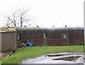
Old Railway Carriage
This old railway carriage appears to be used as a garden store. There are several gardens with old railway carriages being used in this way in South Norfolk and North Suffolk. This does not appear to have been a passenger carriage. It is possible that this was a parcels van or used for the transport of fresh goods, the roof ventilators would suggest it was of at least pre war construction.
Image: © Richard Rice
Taken: 25 Feb 2007
0.04 miles
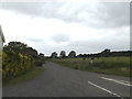
2
The Common and Common Farm
Looking north-westward.
Image: © Peter Wood
Taken: 23 Feb 2020
0.06 miles
3
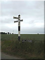
Roadsigns on The Common
At the junction with Bates Lane
Image: © Geographer
Taken: 23 Jun 2015
0.16 miles
4
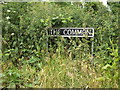
The Common Sign
On The Common at the junction with Bates Lane
Image: © Geographer
Taken: 23 Jun 2015
0.16 miles
5
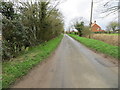
Bates Lane, Fersfield
At the junction with The Common
Image: © Geographer
Taken: 23 Jun 2015
0.16 miles
6
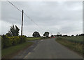
The Common, Fersfield
At the junction with Bates Lane
Image: © Geographer
Taken: 23 Jun 2015
0.16 miles
7
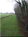
Wood Boundary
Footpath along the edge of Lopham Grove near to Fersfield, Norfolk.
Image: © Keith Evans
Taken: 7 Feb 2010
0.23 miles