IMAGES TAKEN NEAR TO
School Road, DISS, IP22 2AR
Introduction
This page details the photographs taken nearby to School Road, IP22 2AR by members of the Geograph project.
The Geograph project started in 2005 with the aim of publishing, organising and preserving representative images for every square kilometre of Great Britain, Ireland and the Isle of Man.

There are currently over 7.5m images from over14,400 individuals and you can help contribute to the project by visiting https://www.geograph.org.uk
Image Map
Images are licensed for reuse under creativecommons.org/licenses/by-sa/2.0
Notes
- Clicking on the map will re-center to the selected point.
- The higher the marker number, the further away the image location is from the centre of the postcode.
Image Listing (56 Images Found)
Images are licensed for reuse under creativecommons.org/licenses/by-sa/2.0
Image
Details
Distance
1
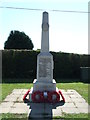
Bressingham War Memorial
War memorial at Bressingham, Norfolk for close up on the list of names see http://www.geograph.org.uk/photo/3122132
Image: © Keith Evans
Taken: 9 Sep 2012
0.03 miles
2
Roll of Honour
List of name on the war memorial at Bressingham, Norfolk for overall view of the memorial see http://www.geograph.org.uk/photo/3122124
Image: © Keith Evans
Taken: 9 Sep 2012
0.03 miles
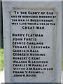
3

Bressingham War Memorial in High Road
There are 12 names for WW1, they are: Harry Flatman, John Fortis, George Garland, Thomas R.Goodswen, George H.Hall, George H.Hoskins, Herbert C.Kent, William L.Leighton, Charles W.Parsley, Victor J.M.Rawlinson, Frank V.Rodwell, John H.Rolfe. The 3 WW2 names are: Douglas C.Hall, Basil T.Harvey, Alec C.Witton.
Image: © Adrian S Pye
Taken: 15 Apr 2015
0.03 miles
4
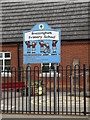
Bressingham Primary School sign
Off School Road
http://www.bressingham.norfolk.sch.uk/
Image: © Geographer
Taken: 23 May 2015
0.03 miles
5
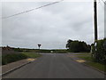
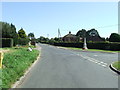
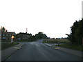
School Road, Bressingham
At the junction with Fersfield & High Roads
Image: © Geographer
Taken: 23 May 2015
0.03 miles
6
Crossroads
Crossroads and War memorial at Bressingham, Norfolk. For close up view of the memorial see http://www.geograph.org.uk/photo/3122124
Image: © Keith Evans
Taken: 9 Sep 2012
0.03 miles
7
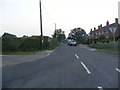
School Road, Bressingham
At the junction with Fersfield & High Roads & Folly Lane
Image: © Geographer
Taken: 4 Sep 2013
0.03 miles
8
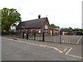
Bressingham Primary School
Off School Road
http://www.bressingham.norfolk.sch.uk/
Image: © Geographer
Taken: 23 May 2015
0.03 miles
9
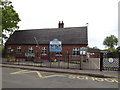
Bressingham Primary School
Off School Road
http://www.bressingham.norfolk.sch.uk/
Image: © Geographer
Taken: 23 May 2015
0.03 miles
10
High Road, Bressingham
At the junction with Fersfield & School Roads & Folly Lane
Image: © Geographer
Taken: 4 Sep 2013
0.03 miles