IMAGES TAKEN NEAR TO
The Ling, DISS, IP22 1ST
Introduction
This page details the photographs taken nearby to The Ling, IP22 1ST by members of the Geograph project.
The Geograph project started in 2005 with the aim of publishing, organising and preserving representative images for every square kilometre of Great Britain, Ireland and the Isle of Man.

There are currently over 7.5m images from over14,400 individuals and you can help contribute to the project by visiting https://www.geograph.org.uk
Image Map
Images are licensed for reuse under creativecommons.org/licenses/by-sa/2.0
Notes
- Clicking on the map will re-center to the selected point.
- The higher the marker number, the further away the image location is from the centre of the postcode.
Image Listing (36 Images Found)
Images are licensed for reuse under creativecommons.org/licenses/by-sa/2.0
Image
Details
Distance
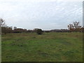
1
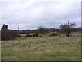
Common at Wortham Ling
Looking towards Rectory Road
Image: © Geographer
Taken: 17 Apr 2013
0.03 miles
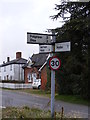
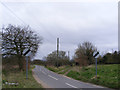
4
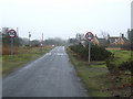
Speed Limit
Speed limit signs Wortham Ling, Suffolk.
Image: © Keith Evans
Taken: 14 Feb 2010
0.04 miles
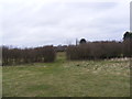
5
Common at Wortham Ling
Near Beehive Cottage
Image: © Geographer
Taken: 29 Nov 2014
0.04 miles
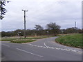
6
Roadsign on Rectory Road
At Old Dick junction
Image: © Geographer
Taken: 17 Apr 2013
0.04 miles
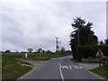
7
Rectory Road, Wortham Ling
At Old Dick junction
Image: © Geographer
Taken: 17 Apr 2013
0.04 miles
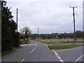
9
Ling Road, Wortham Ling
Looking towards Denmark Bridge at Old Dick junction
Image: © Geographer
Taken: 17 Apr 2013
0.04 miles
10
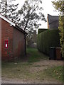
Angles Way footpath
Off Rectory Road at the junction with Ling Road
Image: © Geographer
Taken: 29 Nov 2014
0.05 miles