IMAGES TAKEN NEAR TO
Millway Lane, DISS, IP22 1SN
Introduction
This page details the photographs taken nearby to Millway Lane, IP22 1SN by members of the Geograph project.
The Geograph project started in 2005 with the aim of publishing, organising and preserving representative images for every square kilometre of Great Britain, Ireland and the Isle of Man.

There are currently over 7.5m images from over14,400 individuals and you can help contribute to the project by visiting https://www.geograph.org.uk
Image Map
Images are licensed for reuse under creativecommons.org/licenses/by-sa/2.0
Notes
- Clicking on the map will re-center to the selected point.
- The higher the marker number, the further away the image location is from the centre of the postcode.
Image Listing (20 Images Found)
Images are licensed for reuse under creativecommons.org/licenses/by-sa/2.0
Image
Details
Distance
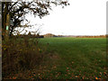
5
Under Offer
The sale board is for 4.54 acres by private treaty near to Roydon, Norfolk.
Image: © Keith Evans
Taken: 27 Feb 2010
0.06 miles
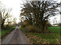
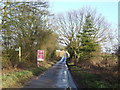
6
Low Water Lane, Wortham
At the junction with Millway Lane
Image: © Geographer
Taken: 29 Nov 2014
0.07 miles
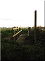
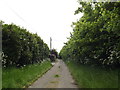
7
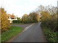
Millway Lane, Wortham
At the junction with Low Water Lane
Image: © Geographer
Taken: 29 Nov 2014
0.08 miles
8
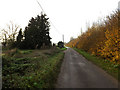
Millway Lane, Wortham
At the junction with Low Water Lane
Image: © Geographer
Taken: 29 Nov 2013
0.09 miles
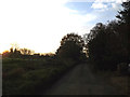
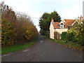
10
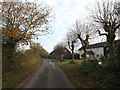
Millway Lane, Wortham
Near Wolsey House
Image: © Geographer
Taken: 29 Nov 2014
0.13 miles