IMAGES TAKEN NEAR TO
Fen Street, DISS, IP22 1SG
Introduction
This page details the photographs taken nearby to Fen Street, IP22 1SG by members of the Geograph project.
The Geograph project started in 2005 with the aim of publishing, organising and preserving representative images for every square kilometre of Great Britain, Ireland and the Isle of Man.

There are currently over 7.5m images from over14,400 individuals and you can help contribute to the project by visiting https://www.geograph.org.uk
Image Map
Images are licensed for reuse under creativecommons.org/licenses/by-sa/2.0
Notes
- Clicking on the map will re-center to the selected point.
- The higher the marker number, the further away the image location is from the centre of the postcode.
Image Listing (5 Images Found)
Images are licensed for reuse under creativecommons.org/licenses/by-sa/2.0
Image
Details
Distance


3
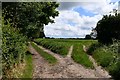
Redgrave: Bier Lane public footpath
Image: © Michael Garlick
Taken: 18 Jun 2020
0.18 miles
4
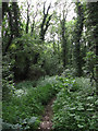
Woodland Trail, Redgrave and Lopham Fen
One of many nature trails, http://www.suffolkwildlifetrust.org/reserves-and-visitor-centres/redgrave-lopham-fen/
Image: © Hugh Venables
Taken: 3 Jul 2010
0.20 miles
5
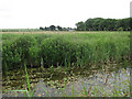
River Waveney
Looking across from the Waveney Trail on Redgrave and Lopham Fen, http://www.suffolkwildlifetrust.org/reserves-and-visitor-centres/redgrave-lopham-fen/
Image: © Hugh Venables
Taken: 3 Jul 2010
0.20 miles