IMAGES TAKEN NEAR TO
Wattisfield Road, DISS, IP22 1JG
Introduction
This page details the photographs taken nearby to Wattisfield Road, IP22 1JG by members of the Geograph project.
The Geograph project started in 2005 with the aim of publishing, organising and preserving representative images for every square kilometre of Great Britain, Ireland and the Isle of Man.

There are currently over 7.5m images from over14,400 individuals and you can help contribute to the project by visiting https://www.geograph.org.uk
Image Map
Images are licensed for reuse under creativecommons.org/licenses/by-sa/2.0
Notes
- Clicking on the map will re-center to the selected point.
- The higher the marker number, the further away the image location is from the centre of the postcode.
Image Listing (6 Images Found)
Images are licensed for reuse under creativecommons.org/licenses/by-sa/2.0
Image
Details
Distance
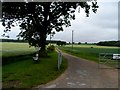
1

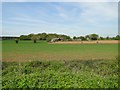
Track to Sandfield Farm
This farm is situated between Hepworth and Wattisfield in North Suffolk.
Image: © Bob Jones
Taken: 18 Aug 2006
0.04 miles
5
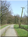
The Leaning Pole Of Wattisfield
Leaning telephone pole near to Wattisfield, Suffolk.
Image: © Keith Evans
Taken: 17 Apr 2010
0.18 miles
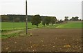
6
New Barn Farm across the fields from Wood View Farm
Image: © Adrian S Pye
Taken: 8 May 2015
0.18 miles