IMAGES TAKEN NEAR TO
Mill Lane, DISS, IP22 1HG
Introduction
This page details the photographs taken nearby to Mill Lane, IP22 1HG by members of the Geograph project.
The Geograph project started in 2005 with the aim of publishing, organising and preserving representative images for every square kilometre of Great Britain, Ireland and the Isle of Man.

There are currently over 7.5m images from over14,400 individuals and you can help contribute to the project by visiting https://www.geograph.org.uk
Image Map
Images are licensed for reuse under creativecommons.org/licenses/by-sa/2.0
Notes
- Clicking on the map will re-center to the selected point.
- The higher the marker number, the further away the image location is from the centre of the postcode.
Image Listing (1 Images Found)
Images are licensed for reuse under creativecommons.org/licenses/by-sa/2.0
Image
Details
Distance
1
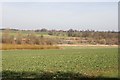
Hinderclay Lakes
The lakes are still being created by the extraction of peat which is sold for use on gardens. The willow seen in the left middle distance is being grown for biofuel and also provides a welcome hiding place for deer. Image
The village of Redgrave is visible on the horizon.
Image: © Charles Greenhough
Taken: 11 Mar 2007
0.25 miles