1
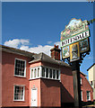
'The Greyhound' inn at Botesdale
Image: © Robert Edwards
Taken: 19 May 2011
0.03 miles
2
The village sign in Botesdale
For a wider view of this location see > http://www.geograph.org.uk/photo/2043905.
Image: © Evelyn Simak
Taken: 31 Aug 2010
0.05 miles
3
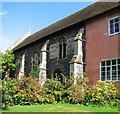
Botesdale Chapel of Ease
This chapel was formerly a chantry chapel but was converted into a school and then reconsecrated in the 19th century as a chapel of ease for Redgrave St Mary's. http://www.geograph.org.uk/photo/2108318 The house adjoining the church was built onto it in the 16th century, after it was converted into a school. The house was home to the schoolmaster and a number of student boarders.
Image: © Adrian S Pye
Taken: 11 Mar 2007
0.05 miles
4
St Botolph's chapel in Botesdale
The house adjoining the church was built onto it in the 16th century, after the church - a former chantry chapel - was converted into a school. The house was home to the schoolmaster and a number of boarders. The school was re-converted and used as a church from the late 19th century onwards and presently serves as a chapel of ease.
Image: © Evelyn Simak
Taken: 31 Aug 2010
0.05 miles
5
The village sign in Botesdale
Image: © Evelyn Simak
Taken: 31 Aug 2010
0.05 miles
6
The Greyhound, Botesdale, Suffolk
The new owners have refurbished the pub sign and used a picture of the owner's dog. Strange greyhound. The accommodation would benefit from an extra "m" as well! The beer is good though.
Image
http://www.georgeanddragonharling.co.uk/greyhound-botesdale/
Image: © Charles Greenhough
Taken: 17 Mar 2007
0.06 miles
7
St Botolph's chapel in Botesdale
The house adjoining the church was built onto it in the 16th century, after the church - a former chantry chapel - was converted into a school. The house was home to the schoolmaster and a number of boarders. The school was re-converted and used as a church from the late 19th century onwards and presently serves as a chapel of ease.
Image: © Evelyn Simak
Taken: 31 Aug 2010
0.06 miles
8
St Botolph's chapel in Botesdale - old graffiti
For a view of the chapel see > http://www.geograph.org.uk/photo/2043912.
Image: © Evelyn Simak
Taken: 31 Aug 2010
0.06 miles
9
St Botolph's chapel in Botesdale
The house adjoining the church was built onto it in the 16th century, after the church - a former chantry chapel - was converted into a school. The house was home to the schoolmaster and a number of boarders. The school was re-converted and used as a church from the late 19th century onwards and presently serves as a chapel of ease.
Image: © Evelyn Simak
Taken: 31 Aug 2010
0.06 miles
10
St Botolph's chapel in Botesdale - benchmark
This cut mark can be found on the north-east corner of St Botolph's chapel > http://www.geograph.org.uk/photo/2043912. It is listed in the Bench Marks Database: http://www.bench-marks.org.uk/bm35370.
Image: © Evelyn Simak
Taken: 31 Aug 2010
0.06 miles


