IMAGES TAKEN NEAR TO
Harleston Road, EYE, IP21 5TE
Introduction
This page details the photographs taken nearby to Harleston Road, IP21 5TE by members of the Geograph project.
The Geograph project started in 2005 with the aim of publishing, organising and preserving representative images for every square kilometre of Great Britain, Ireland and the Isle of Man.

There are currently over 7.5m images from over14,400 individuals and you can help contribute to the project by visiting https://www.geograph.org.uk
Image Map
Images are licensed for reuse under creativecommons.org/licenses/by-sa/2.0
Notes
- Clicking on the map will re-center to the selected point.
- The higher the marker number, the further away the image location is from the centre of the postcode.
Image Listing (22 Images Found)
Images are licensed for reuse under creativecommons.org/licenses/by-sa/2.0
Image
Details
Distance
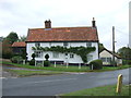
1
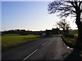
Entering Fressingfield on the B1116 Harleston Road
Image: © Geographer
Taken: 9 Dec 2011
0.03 miles
2

Footpath
Footpath looking east near to Fressingfield, Suffolk.
Image: © Keith Evans
Taken: 19 Jun 2014
0.07 miles
3
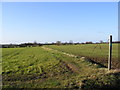
Footpath to Dale Road
Off the B1116 Harleston Road
Image: © Geographer
Taken: 9 Dec 2011
0.07 miles
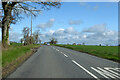
4

The B1116
Looking north along the B1116 just north of Fressingfield, Suffolk.
Image: © Keith Evans
Taken: 19 Jun 2014
0.08 miles
5

Footpath And Sign
Footpath leading to Vales Hall near to Fressingfield, Suffolk.
Image: © Keith Evans
Taken: 19 Jun 2014
0.08 miles
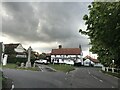
6
B1116 heading north
Towards Harleston.
Image: © Robin Webster
Taken: 7 Apr 2023
0.11 miles
9
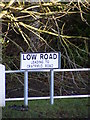
Low Road sign
At the junction with the B1116 Harleston Road
Image: © Geographer
Taken: 9 Dec 2011
0.23 miles
10
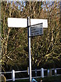
Roadsign on the B1116 Harleston Road
At the junction with Low Road
Image: © Geographer
Taken: 9 Dec 2011
0.23 miles