IMAGES TAKEN NEAR TO
The Low, EYE, IP21 5QP
Introduction
This page details the photographs taken nearby to The Low, IP21 5QP by members of the Geograph project.
The Geograph project started in 2005 with the aim of publishing, organising and preserving representative images for every square kilometre of Great Britain, Ireland and the Isle of Man.

There are currently over 7.5m images from over14,400 individuals and you can help contribute to the project by visiting https://www.geograph.org.uk
Image Map
Images are licensed for reuse under creativecommons.org/licenses/by-sa/2.0
Notes
- Clicking on the map will re-center to the selected point.
- The higher the marker number, the further away the image location is from the centre of the postcode.
Image Listing (86 Images Found)
Images are licensed for reuse under creativecommons.org/licenses/by-sa/2.0
Image
Details
Distance
1
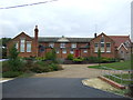
Former school, Fressingfield
Now converted into housing.
Image: © JThomas
Taken: 13 Oct 2016
0.02 miles
2
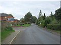
Cratfield Road, Fressingfield
Looking north west.
Image: © JThomas
Taken: 13 Oct 2016
0.05 miles
3
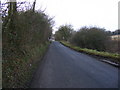
Cratfield Road, Freshingfield
Looking towards Fressingfield
Image: © Geographer
Taken: 28 Dec 2008
0.06 miles
5
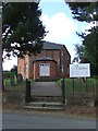
Fressingfield Baptist Church
Fressingfield baptist church Fressingfield, Suffolk.
Image: © Keith Evans
Taken: 12 Sep 2013
0.07 miles
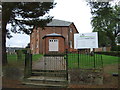
6
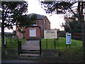
Fressingfield Baptist Church
Off Cratfield Road
Image: © Geographer
Taken: 28 Dec 2008
0.07 miles
7
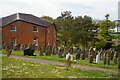
Fressingfield: Baptist chapel and graveyard
Image: © Christopher Hilton
Taken: 9 May 2021
0.07 miles
8
Fressingfield Baptist Church
Off Cratfield Road
Image: © Geographer
Taken: 28 Dec 2008
0.07 miles
9
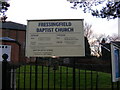
Fressingfield Baptist Church notice board
Image: © Geographer
Taken: 28 Dec 2008
0.07 miles
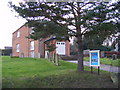
10
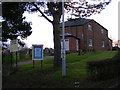
Fressingfield Baptist Church
Off Cratfield Road
Image: © Geographer
Taken: 28 Dec 2008
0.07 miles