IMAGES TAKEN NEAR TO
Harleston Road, EYE, IP21 5PE
Introduction
This page details the photographs taken nearby to Harleston Road, IP21 5PE by members of the Geograph project.
The Geograph project started in 2005 with the aim of publishing, organising and preserving representative images for every square kilometre of Great Britain, Ireland and the Isle of Man.

There are currently over 7.5m images from over14,400 individuals and you can help contribute to the project by visiting https://www.geograph.org.uk
Image Map
Images are licensed for reuse under creativecommons.org/licenses/by-sa/2.0
Notes
- Clicking on the map will re-center to the selected point.
- The higher the marker number, the further away the image location is from the centre of the postcode.
Image Listing (84 Images Found)
Images are licensed for reuse under creativecommons.org/licenses/by-sa/2.0
Image
Details
Distance
1
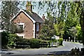
Fressingfield: Detached house on Harleston Hill
Image: © Michael Garlick
Taken: 24 Apr 2020
0.01 miles
2
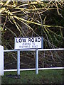
Low Road sign
At the junction with the B1116 Harleston Road
Image: © Geographer
Taken: 9 Dec 2011
0.01 miles
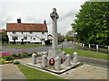
4

Roll of Honour
Roll of honour on the village war memorial at Fressingfield, Suffolk; for other roll see http://www.geograph.org.uk/photo/4040601 and for overall view of the memorial http://www.geograph.org.uk/photo/4040598
Image: © Keith Evans
Taken: 19 Jun 2014
0.01 miles
5

Roll of Honour
Roll of honour on the village war memorial at Fressingfield, Suffolk; for other roll see http://www.geograph.org.uk/photo/4040604 and for overall view of the memorial http://www.geograph.org.uk/photo/4040598
Image: © Keith Evans
Taken: 19 Jun 2014
0.01 miles
6

Village War Memorial
The village war memorial for Fressingfield, Suffolk; for views of the rolls of honour see http://www.geograph.org.uk/photo/4040601 and http://www.geograph.org.uk/photo/4040604
Image: © Keith Evans
Taken: 19 Jun 2014
0.01 miles

8
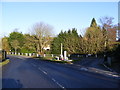
B1116 Harleston Road
At the junction with Low Road
Image: © Geographer
Taken: 9 Dec 2011
0.01 miles
10
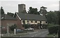
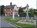
Fressingfield Church and War Memorial
The Church of St Peter and St Paul is a magnificent church dominating the countryside and can be seen a couple of miles away.
Beneath the church are the Swan Inn (shown) and the Fox and Goose public houses. Also shown in the picture in the foreground next to the war memorial is the village pump which has been restored.
Image: © Mike Snoswell
Taken: 21 Aug 2005
0.01 miles