IMAGES TAKEN NEAR TO
London City Road, EYE, IP21 5LT
Introduction
This page details the photographs taken nearby to London City Road, IP21 5LT by members of the Geograph project.
The Geograph project started in 2005 with the aim of publishing, organising and preserving representative images for every square kilometre of Great Britain, Ireland and the Isle of Man.

There are currently over 7.5m images from over14,400 individuals and you can help contribute to the project by visiting https://www.geograph.org.uk
Image Map
Images are licensed for reuse under creativecommons.org/licenses/by-sa/2.0
Notes
- Clicking on the map will re-center to the selected point.
- The higher the marker number, the further away the image location is from the centre of the postcode.
Image Listing (13 Images Found)
Images are licensed for reuse under creativecommons.org/licenses/by-sa/2.0
Image
Details
Distance
1
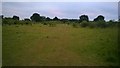
Wilby: Ploughed field on which a pair of yellowhammers are feeding
Image: © Michael Garlick
Taken: 25 Mar 2022
0.09 miles
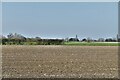
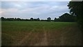
2
Wilby - Maize Field & Large Willow
Looking across a small maize field with a large willow visible on the left.
Image: © wilbysuffolk
Taken: 10 Jul 2015
0.14 miles
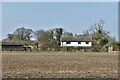
3
Wilby - Set Aside Field
Looking across a well developed set aside field towards Wilby House.
Image: © wilbysuffolk
Taken: 10 Jul 2015
0.16 miles
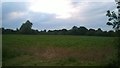
4
Wilby - Barley View footpath
Looking across the Barley View - Foals Green footpath & a maize field.
Image: © wilbysuffolk
Taken: 10 Jul 2015
0.16 miles
5
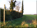
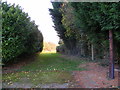
Footpath to the B1117 & Neaves Road
Off London City Road
Image: © Geographer
Taken: 15 Nov 2011
0.16 miles
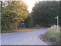
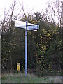
8
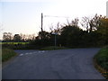
Road junction on London City Road at Russel's Green
Image: © Geographer
Taken: 15 Nov 2011
0.19 miles