IMAGES TAKEN NEAR TO
Reading Green, EYE, IP21 5DL
Introduction
This page details the photographs taken nearby to Reading Green, IP21 5DL by members of the Geograph project.
The Geograph project started in 2005 with the aim of publishing, organising and preserving representative images for every square kilometre of Great Britain, Ireland and the Isle of Man.

There are currently over 7.5m images from over14,400 individuals and you can help contribute to the project by visiting https://www.geograph.org.uk
Image Map
Images are licensed for reuse under creativecommons.org/licenses/by-sa/2.0
Notes
- Clicking on the map will re-center to the selected point.
- The higher the marker number, the further away the image location is from the centre of the postcode.
Image Listing (6 Images Found)
Images are licensed for reuse under creativecommons.org/licenses/by-sa/2.0
Image
Details
Distance
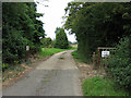
1
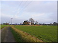
Locks Farm & Locks Farm Lane, Reading Green
Image: © Geographer
Taken: 21 Nov 2011
0.02 miles
3
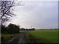
Locks Farm Lane, Reading Green
Looking towards Watering Road near Locks Farm
Image: © Geographer
Taken: 21 Nov 2011
0.05 miles
4
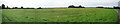
So what do you expect from an old airfield?
One of many, many in Suffolk and Norfolk, this area was an airfield in the Second World War. Now restored as farmland, it still bears some of the cleared open feeling it must have had then.
Image: © Zorba the Geek
Taken: 5 Sep 2007
0.14 miles
5
No great welcome at Maggotts Farm
Although the gate is open, this end-of-the-road farm deters callers with two signs: "Private Property No Admittance" and "Notice Keep Out". I'll be dropping by for coffee, then. Not.
Image: © Zorba the Geek
Taken: 5 Sep 2007
0.18 miles
6
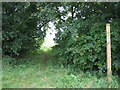
Out of the darkness and into the light
Close to Image, this footpath entrance offers an escape route towards Thorpe Hall (in Gothic script in Explorer) and with two mentions of Moat (ditto) - always intriguing.
Image: © Zorba the Geek
Taken: 5 Sep 2007
0.19 miles