IMAGES TAKEN NEAR TO
Church Hill, EYE, IP21 5AT
Introduction
This page details the photographs taken nearby to Church Hill, IP21 5AT by members of the Geograph project.
The Geograph project started in 2005 with the aim of publishing, organising and preserving representative images for every square kilometre of Great Britain, Ireland and the Isle of Man.

There are currently over 7.5m images from over14,400 individuals and you can help contribute to the project by visiting https://www.geograph.org.uk
Image Map
Images are licensed for reuse under creativecommons.org/licenses/by-sa/2.0
Notes
- Clicking on the map will re-center to the selected point.
- The higher the marker number, the further away the image location is from the centre of the postcode.
Image Listing (166 Images Found)
Images are licensed for reuse under creativecommons.org/licenses/by-sa/2.0
Image
Details
Distance
1
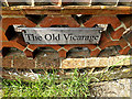
The Old Vicarage sign
Off the B1118 Green Street near St.Peter & St.Paul Church
Image: © Geographer
Taken: 17 May 2014
0.01 miles
2
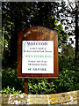
Notice Board of St.Peter & St.Paul Church, Hoxne
Off the B1118 Green Street
Image: © Geographer
Taken: 17 May 2014
0.01 miles
3
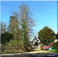
Entrance to St.Peter & St.Paul Church & The Old Vicarage
Off the B1118 Green Street
Image: © Geographer
Taken: 17 May 2014
0.01 miles
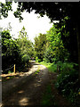
5
Path to Low Street
Off the B1118 Green Street
Image: © Geographer
Taken: 23 Jun 2015
0.02 miles
7
Path to Low Street
Off the B1118 Green Street
Image: © Geographer
Taken: 23 Jun 2015
0.02 miles
8
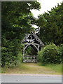
Lych Gate of St.Peter & St.Paul's Church
Off the B1118 Green Street
Image: © Geographer
Taken: 23 Jun 2015
0.02 miles
9
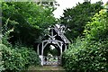
Hoxne, St. Peter and St. Paul Church: Lych gate
Image: © Michael Garlick
Taken: 18 Jul 2020
0.02 miles