IMAGES TAKEN NEAR TO
The Close, EYE, IP21 5AG
Introduction
This page details the photographs taken nearby to The Close, IP21 5AG by members of the Geograph project.
The Geograph project started in 2005 with the aim of publishing, organising and preserving representative images for every square kilometre of Great Britain, Ireland and the Isle of Man.

There are currently over 7.5m images from over14,400 individuals and you can help contribute to the project by visiting https://www.geograph.org.uk
Image Map
Images are licensed for reuse under creativecommons.org/licenses/by-sa/2.0
Notes
- Clicking on the map will re-center to the selected point.
- The higher the marker number, the further away the image location is from the centre of the postcode.
Image Listing (45 Images Found)
Images are licensed for reuse under creativecommons.org/licenses/by-sa/2.0
Image
Details
Distance
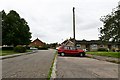
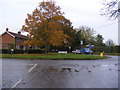
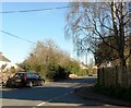
3
Wittons Lane
Near the junction with Chickering Road & Cross Street in Hoxne
Image: © Geographer
Taken: 10 Jan 2012
0.13 miles
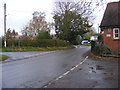
5
Clink Hill
At the junction of Cross Street, Heckfield Green
Image: © Geographer
Taken: 21 Nov 2011
0.13 miles
6
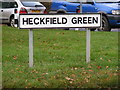
Heckfield Green sign
At the junction with Clink Hill
Image: © Geographer
Taken: 21 Nov 2011
0.13 miles
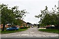
7
Cross Street, Heckfield Green
At the junction of Wittons & Chickering Lanes
Image: © Geographer
Taken: 21 Nov 2011
0.14 miles
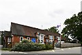
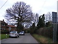
10
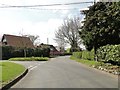
Road junction and Hoxne school at Heckfield Green
Image: © Adrian S Pye
Taken: 1 Apr 2014
0.14 miles