IMAGES TAKEN NEAR TO
Ducksfoot Lane, DISS, IP21 4YD
Introduction
This page details the photographs taken nearby to Ducksfoot Lane, IP21 4YD by members of the Geograph project.
The Geograph project started in 2005 with the aim of publishing, organising and preserving representative images for every square kilometre of Great Britain, Ireland and the Isle of Man.

There are currently over 7.5m images from over14,400 individuals and you can help contribute to the project by visiting https://www.geograph.org.uk
Image Map
Images are licensed for reuse under creativecommons.org/licenses/by-sa/2.0
Notes
- Clicking on the map will re-center to the selected point.
- The higher the marker number, the further away the image location is from the centre of the postcode.
Image Listing (6 Images Found)
Images are licensed for reuse under creativecommons.org/licenses/by-sa/2.0
Image
Details
Distance
1
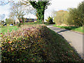
House by the junction of Barnes Road and Poppy's Lane
Image: © Evelyn Simak
Taken: 7 Nov 2010
0.02 miles
2
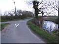
Pond beside Junction, Barnes' Road
Junction of Barnes' Road, Duck's Foot Road and Poppy's Lane
Image: © Ian Robertson
Taken: 18 Mar 2007
0.02 miles
3
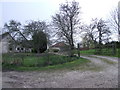
Gate and Track, Hill Farm, Pulham Market
Image: © Ian Robertson
Taken: 18 Mar 2007
0.11 miles
4
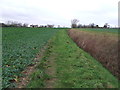
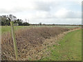
Looking West
Footpath looking west near to Bush Green, Norfolk.
Image: © Keith Evans
Taken: 12 Jan 2016
0.21 miles
6
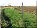
Public footpath to Colegate End
It links Hardwick Road and Colegate East Road, further to the west.
Image: © Evelyn Simak
Taken: 7 Nov 2010
0.22 miles