IMAGES TAKEN NEAR TO
North Green Road, DISS, IP21 4XW
Introduction
This page details the photographs taken nearby to North Green Road, IP21 4XW by members of the Geograph project.
The Geograph project started in 2005 with the aim of publishing, organising and preserving representative images for every square kilometre of Great Britain, Ireland and the Isle of Man.

There are currently over 7.5m images from over14,400 individuals and you can help contribute to the project by visiting https://www.geograph.org.uk
Image Map
Images are licensed for reuse under creativecommons.org/licenses/by-sa/2.0
Notes
- Clicking on the map will re-center to the selected point.
- The higher the marker number, the further away the image location is from the centre of the postcode.
Image Listing (10 Images Found)
Images are licensed for reuse under creativecommons.org/licenses/by-sa/2.0
Image
Details
Distance
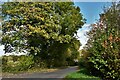
2

Road Junction
Road junction in the shade near to Hardwick, Norfolk.
Image: © Keith Evans
Taken: 7 Oct 2010
0.03 miles
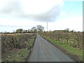
6

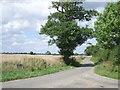
Minor Road
Wood Lane looking east near to Hardwick, Norfolk.
Image: © Keith Evans
Taken: 7 Oct 2010
0.15 miles
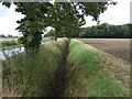
8
Field towards Bale's Plantation
North of Wood Lane.
Image: © JThomas
Taken: 12 Oct 2016
0.19 miles