IMAGES TAKEN NEAR TO
Valley Lane, DISS, IP21 4UE
Introduction
This page details the photographs taken nearby to Valley Lane, IP21 4UE by members of the Geograph project.
The Geograph project started in 2005 with the aim of publishing, organising and preserving representative images for every square kilometre of Great Britain, Ireland and the Isle of Man.

There are currently over 7.5m images from over14,400 individuals and you can help contribute to the project by visiting https://www.geograph.org.uk
Image Map
Images are licensed for reuse under creativecommons.org/licenses/by-sa/2.0
Notes
- Clicking on the map will re-center to the selected point.
- The higher the marker number, the further away the image location is from the centre of the postcode.
Image Listing (38 Images Found)
Images are licensed for reuse under creativecommons.org/licenses/by-sa/2.0
Image
Details
Distance
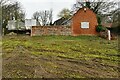
1
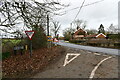
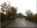
Burston and Shimpling: Where Valley lane joins Station Road
Image: © Michael Garlick
Taken: 3 Feb 2023
0.06 miles
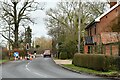
3
Station Road
House on Station Road Shimpling, Norfolk.
Image: © Keith Evans
Taken: 16 Aug 2012
0.09 miles
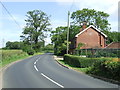
4
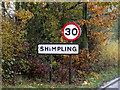
Entering Shimpling
Village name sign as you enter Shimpling, Norfolk.
Image: © Keith Evans
Taken: 16 Aug 2012
0.13 miles
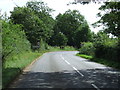
5
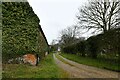
Entering Shimpling on Station Road
Road No.C205
Image: © Geographer
Taken: 22 Nov 2014
0.13 miles
6
Shimpling Village Name sign on Station Road
Road No.C205
Image: © Geographer
Taken: 22 Nov 2014
0.13 miles
10
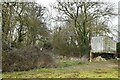
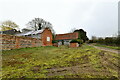
Shimpling: Public footpath through a small wooded area
Image: © Michael Garlick
Taken: 1 Mar 2023
0.17 miles