IMAGES TAKEN NEAR TO
The Green, DISS, IP21 4SU
Introduction
This page details the photographs taken nearby to The Green, IP21 4SU by members of the Geograph project.
The Geograph project started in 2005 with the aim of publishing, organising and preserving representative images for every square kilometre of Great Britain, Ireland and the Isle of Man.

There are currently over 7.5m images from over14,400 individuals and you can help contribute to the project by visiting https://www.geograph.org.uk
Image Map
Images are licensed for reuse under creativecommons.org/licenses/by-sa/2.0
Notes
- Clicking on the map will re-center to the selected point.
- The higher the marker number, the further away the image location is from the centre of the postcode.
Image Listing (164 Images Found)
Images are licensed for reuse under creativecommons.org/licenses/by-sa/2.0
Image
Details
Distance
1
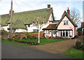
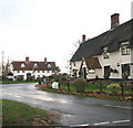
Thatched cottages on the village green
Pulham Market is an award winning conservation village in South Norfolk. It is built on high ground to the north of a small stream known as The Beck. Its origins date back at least to the 10th century, when the land belonged to Ethelwold, the Bishop of Winchester, who later gave it to the abbey of St Ethelred at Ely. By the 14th century the village had become sufficiently wealthy to build its own church, St Mary Magdalene > http://www.geograph.org.uk/photo/1594078. In Tudor times the village was famous for its cottage industries but when the market lost its appeal because of the larger one at Harleston many of the cottage industries were dispersed to other parts of Norfolk. The village boasts a number of old buildings > http://www.geograph.org.uk/photo/1594098 which are listed as being of architectural and historic interest. The green is surrounded by thatched cottages > http://www.geograph.org.uk/photo/1594055 as well as a general store and post office > http://www.geograph.org.uk/photo/1594035 and a pub on each end: The Falcon > http://www.geograph.org.uk/photo/1594037 in the north and the 17th century Crown at the other end, with the parish church towering over it > http://www.geograph.org.uk/photo/1594022. Until the 1950s the village was served by the Waveney Valley Railway line > http://www.geograph.org.uk/photo/1592892 which ran from the east coast to the main Norwich to London Line at Tivetshall. The line was closed in 1966.
Image: © Evelyn Simak
Taken: 23 Nov 2009
0.01 miles
2
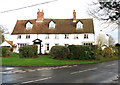
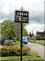
Drayton House
Drayton House is situated by the south-eastern corner of the village green, beside Harleston Road.
Pulham Market is an award winning conservation village in South Norfolk. It is built on high ground to the north of a small stream known as The Beck. Its origins date back at least to the 10th century, when the land belonged to Ethelwold, the Bishop of Winchester, who later gave it to the abbey of St Ethelred at Ely. By the 14th century the village had become sufficiently wealthy to build its own church, St Mary Magdalene > http://www.geograph.org.uk/photo/1594078. In Tudor times the village was famous for its cottage industries but when the market lost its appeal because of the larger one at Harleston many of the cottage industries were dispersed to other parts of Norfolk. The village boasts a number of old buildings > http://www.geograph.org.uk/photo/1594098 which are listed as being of architectural and historic interest. The green is surrounded by thatched cottages > http://www.geograph.org.uk/photo/1594055 as well as a general store and post office > http://www.geograph.org.uk/photo/1594035 and a pub on each end: The Falcon > http://www.geograph.org.uk/photo/1594037 in the north and the 17th century Crown at the other end, with the parish church towering over it > http://www.geograph.org.uk/photo/1594022. Until the 1950s the village was served by the Waveney Valley Railway line > http://www.geograph.org.uk/photo/1592892 which ran from the east coast to the main Norwich to London Line at Tivetshall. The line was closed in 1966.
Image: © Evelyn Simak
Taken: 23 Nov 2009
0.02 miles
3
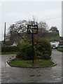
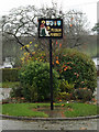
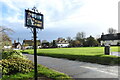
Pulham Market Village sign
Off Station Road on The Green
Image: © Geographer
Taken: 22 Nov 2014
0.02 miles
4
Pulham Market Village sign
Off Station Road on The Green
(close up)
Image: © Geographer
Taken: 22 Nov 2014
0.02 miles
5
Pulham Market Village sign
Off Station Road on The Green
Image: © Geographer
Taken: 22 Nov 2014
0.02 miles
6
Pulham Market Village sign
Off Station Road on The Green
Image: © Geographer
Taken: 22 Nov 2014
0.02 miles
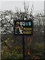
8
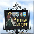
Pulham Market village sign
The sign is in recognition of the church of St. Mary Magdalene who is pictured washing the feet of Jesus.
The other four emblems in the shields are in recognition of the public houses which once stood in the village. The Falcon, The Crown, The Ducks Foot and The Queens Head. Only the Falcon remains. https://www.geograph.org.uk/photo/6676612
Image: © Adrian S Pye
Taken: 15 Nov 2020
0.02 miles
9
Pulham Market village sign
The sign is in recognition of the church of St. Mary Magdalene who is pictured washing the feet of Jesus.
The other four emblems in the shields are in recognition of the public houses which once stood in the village. The Falcon, The Crown, The Ducks Foot and The Queens Head. Only the Falcon remains. https://www.geograph.org.uk/photo/6676609
Image: © Adrian S Pye
Taken: 15 Nov 2020
0.02 miles
10
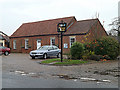
Junction of Station Road with Bank Street
The Crown public house can be seen at right, the building seen in the background is Drayton House.
Pulham Market is an award winning conservation village in South Norfolk. It is built on high ground to the north of a small stream known as The Beck. Its origins date back at least to the 10th century, when the land belonged to Ethelwold, the Bishop of Winchester, who later gave it to the abbey of St Ethelred at Ely. By the 14th century the village had become sufficiently wealthy to build its own church, St Mary Magdalene > http://www.geograph.org.uk/photo/1594078. In Tudor times the village was famous for its cottage industries but when the market lost its appeal because of the larger one at Harleston many of the cottage industries were dispersed to other parts of Norfolk. The village boasts a number of old buildings > http://www.geograph.org.uk/photo/1594098 which are listed as being of architectural and historic interest. The green is surrounded by thatched cottages > http://www.geograph.org.uk/photo/1594055 as well as a general store and post office > http://www.geograph.org.uk/photo/1594035 and a pub on each end: The Falcon > http://www.geograph.org.uk/photo/1594037 in the north and the 17th century Crown at the other end, with the parish church towering over it > http://www.geograph.org.uk/photo/1594022. Until the 1950s the village was served by the Waveney Valley Railway line > http://www.geograph.org.uk/photo/1592892 which ran from the east coast to the main Norwich to London Line at Tivetshall. The line was closed in 1966.
Image: © Evelyn Simak
Taken: 23 Nov 2009
0.02 miles