IMAGES TAKEN NEAR TO
Harleston Road, DISS, IP21 4RT
Introduction
This page details the photographs taken nearby to Harleston Road, IP21 4RT by members of the Geograph project.
The Geograph project started in 2005 with the aim of publishing, organising and preserving representative images for every square kilometre of Great Britain, Ireland and the Isle of Man.

There are currently over 7.5m images from over14,400 individuals and you can help contribute to the project by visiting https://www.geograph.org.uk
Image Map
Images are licensed for reuse under creativecommons.org/licenses/by-sa/2.0
Notes
- Clicking on the map will re-center to the selected point.
- The higher the marker number, the further away the image location is from the centre of the postcode.
Image Listing (11 Images Found)
Images are licensed for reuse under creativecommons.org/licenses/by-sa/2.0
Image
Details
Distance
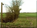
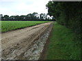
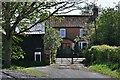
1
Footpaths and Burnthouse Lane
Footpath off both sides of this country road near to Rushall, Norfolk.
Image: © Keith Evans
Taken: 9 Aug 2012
0.02 miles
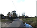
2
Footpath
Footpath next to wire fencing near to Rushall, Norfolk.
Image: © Keith Evans
Taken: 9 Aug 2012
0.10 miles
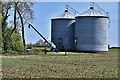
7
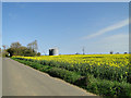
Grain silos and oilseed rape in flower
Image: © Adrian S Pye
Taken: 16 Apr 2015
0.18 miles