IMAGES TAKEN NEAR TO
Doctors Lane, DISS, IP21 4RJ
Introduction
This page details the photographs taken nearby to Doctors Lane, IP21 4RJ by members of the Geograph project.
The Geograph project started in 2005 with the aim of publishing, organising and preserving representative images for every square kilometre of Great Britain, Ireland and the Isle of Man.

There are currently over 7.5m images from over14,400 individuals and you can help contribute to the project by visiting https://www.geograph.org.uk
Image Map
Images are licensed for reuse under creativecommons.org/licenses/by-sa/2.0
Notes
- Clicking on the map will re-center to the selected point.
- The higher the marker number, the further away the image location is from the centre of the postcode.
Image Listing (23 Images Found)
Images are licensed for reuse under creativecommons.org/licenses/by-sa/2.0
Image
Details
Distance
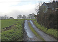
1
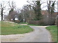
Footpath Crosses Doctor's Lane at Crossingford Lodge
Image: © Ian Robertson
Taken: 18 Mar 2007
0.04 miles
2
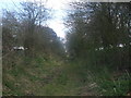
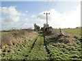
Trackbed looking towards Harleston
In a small cutting. The old trackbed of the Waveney valley railway closed in the 1960s.
Image: © Ashley Dace
Taken: 29 Mar 2009
0.11 miles
3
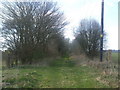
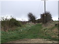
Trackbed looking towards Pulham St Mary
The two gate posts seen on either side.The old trackbed of the Waveney valley railway closed in the 1960s.
Image: © Ashley Dace
Taken: 29 Mar 2009
0.12 miles
4
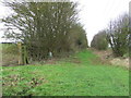
Old Trackbed
Old route of former railway line near to Pulham St. Mary, Norfolk.
Image: © Keith Evans
Taken: 12 Jan 2016
0.13 miles
5
Dismantled railway trackbed twixt Pulham St Mary and Starston
Looking south-east towards Starston
Image: © Adrian S Pye
Taken: 8 Feb 2015
0.14 miles
6
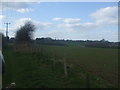
Line side fencing
The old trackbed of the Waveney valley railway closed in the 1960s. Pulham St Mary visible on the right.
Image: © Ashley Dace
Taken: 29 Mar 2009
0.17 miles
7
Looking along Disused Railway Line
South East of Pulham St. Mary
Image: © Ian Robertson
Taken: 18 Mar 2007
0.17 miles
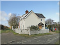
8
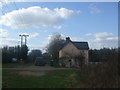
The old crossing keepers hut at Doctor's lane
The old trackbed of the Waveney valley railway closed in the 1960s. The gates on the right are on the wrong side. They were originally from Mellis station. Thanks to Evelyn Simak http://www.geograph.org.uk/profile/14840 for this information.
Image: © Ashley Dace
Taken: 29 Mar 2009
0.19 miles
9
The location of the Crossingford railway crossing
The crossing #24, gatekeeper's house can be seen here Image
Image: © Adrian S Pye
Taken: 9 Dec 2022
0.19 miles
10
The old gatekeepers cottage in Doctor's Lane. Pulham
The old trackbed runs to the left of the gatehouse towards Pulham and on to Tivetshall.
Image: © Adrian S Pye
Taken: 8 Feb 2015
0.21 miles