IMAGES TAKEN NEAR TO
North Green Road, DISS, IP21 4QZ
Introduction
This page details the photographs taken nearby to North Green Road, IP21 4QZ by members of the Geograph project.
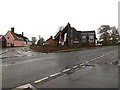
The Geograph project started in 2005 with the aim of publishing, organising and preserving representative images for every square kilometre of Great Britain, Ireland and the Isle of Man.

There are currently over 7.5m images from over14,400 individuals and you can help contribute to the project by visiting https://www.geograph.org.uk
Image Map
Images are licensed for reuse under creativecommons.org/licenses/by-sa/2.0
Notes
- Clicking on the map will re-center to the selected point.
- The higher the marker number, the further away the image location is from the centre of the postcode.
Image Listing (148 Images Found)
Images are licensed for reuse under creativecommons.org/licenses/by-sa/2.0
Image
Details
Distance
1
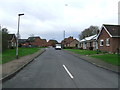
Chestnut Road
Chestnut Road at Pulham St. Mary, Norfolk.
Image: © Keith Evans
Taken: 12 Jan 2016
0.06 miles
2
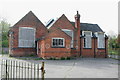
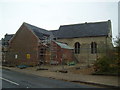
The Old School, Pulham St Marys
But round the back is the Guild Chapel of St James. The site is now being restored with the help of a heritage lottery grant. Part of the school has been demolished (the parts with the circles on). The chapel is now visible from the view point.
The school closed in 1988, it was featured on the BBC's Restoration programme in 2006.
Image: © Duncan Grey
Taken: 3 May 2008
0.08 miles
3
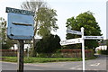
Village Signs
The signposts are self explanatory, however the village sign recalls dirigible balloons in the area.
Ian Crump explains that the sign relates to the WW1 Royal Navy Air Service base for Airships that was located in the fields south of the village until about the mid 1920's. The R24 and R33 were both flown from here at different times. No trace of this large establishment remains above ground, after the huge hangars were dismantled and I believe relocated to Cardington near Bedford.
Image: © Duncan Grey
Taken: 3 May 2008
0.10 miles
4
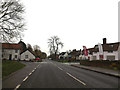
North Green Road, Pulham St Mary
At the junction with Norwich & Station Roads & The Street
Image: © Geographer
Taken: 22 Nov 2014
0.11 miles
5

North Green Road, Pulham St Mary
At the junction with Norwich & Station Roads & The Street
Image: © Geographer
Taken: 22 Nov 2014
0.11 miles
6
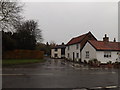
The old School
Medieval Guild Chapel, built in 1401. A free school was founded in the chapel in 1670 by William Pennoyer; it was extended in around 1870 but eventually closed in 1988.
Being converted with council and lottery money by local builders (Harleston)
Image: © Ashley Dace
Taken: 27 Nov 2009
0.11 miles
7
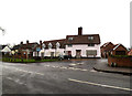
Norwich Road, Pulham St Mary
At the junction with The Street, Station & North Green Roads
Road No.C877
Image: © Geographer
Taken: 22 Nov 2014
0.11 miles
8
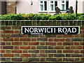
Norwich Road sign
On Norwich Road at the junction with The Street, North Green & Station Roads
Road No.C877
Image: © Geographer
Taken: 22 Nov 2014
0.11 miles
9
Station Road, Pulham St Mary
At the junction with Norwich & North Green Roads & The Street
Image: © Geographer
Taken: 22 Nov 2014
0.11 miles
10
Norwich Road, Pulham St Mary
At the junction with The Street, North Green & Station Roads
Road No.C877
Image: © Geographer
Taken: 22 Nov 2014
0.11 miles