IMAGES TAKEN NEAR TO
Mill Lane, DISS, IP21 4QY
Introduction
This page details the photographs taken nearby to Mill Lane, IP21 4QY by members of the Geograph project.
The Geograph project started in 2005 with the aim of publishing, organising and preserving representative images for every square kilometre of Great Britain, Ireland and the Isle of Man.

There are currently over 7.5m images from over14,400 individuals and you can help contribute to the project by visiting https://www.geograph.org.uk
Image Map
Images are licensed for reuse under creativecommons.org/licenses/by-sa/2.0
Notes
- Clicking on the map will re-center to the selected point.
- The higher the marker number, the further away the image location is from the centre of the postcode.
Image Listing (63 Images Found)
Images are licensed for reuse under creativecommons.org/licenses/by-sa/2.0
Image
Details
Distance
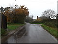
1
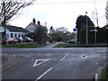
Crossroads, Norwich Road, Pulham St. Mary
Image: © Ian Robertson
Taken: 18 Mar 2007
0.06 miles
2
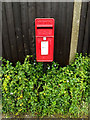
Station Road Postbox
On Station Road
Postbox No.IP21 7124
(Close up)
Image: © Geographer
Taken: 22 Nov 2014
0.10 miles
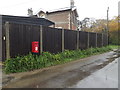
3
Station Road Postbox
On Station Road
Postbox No.IP21 7124
Image: © Geographer
Taken: 22 Nov 2014
0.10 miles
4
Station Road Postbox
On Station Road
Postbox No.IP21 7124
Image: © Geographer
Taken: 22 Nov 2014
0.10 miles
6
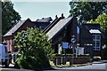
Pulham St. Mary: The Pennoyer Centre
Image: © Michael Garlick
Taken: 22 Jun 2018
0.15 miles
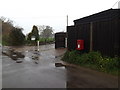
7
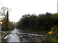
Station Road, Pulham Market
At the junction with Mill Lane
Image: © Geographer
Taken: 22 Nov 2014
0.16 miles
8

Pulham St Mary Conference & Meeting Room
On Norwich Road at the junction with Station,North Green Roads & The Street
(Close up)
Image: © Geographer
Taken: 22 Nov 2014
0.16 miles
9
Norwich Road, Pulham St Mary
At the junction with The Street, North Green & Station Roads
Road No.C877
Image: © Geographer
Taken: 22 Nov 2014
0.16 miles
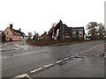
10
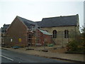
The old School
Medieval Guild Chapel, built in 1401. A free school was founded in the chapel in 1670 by William Pennoyer; it was extended in around 1870 but eventually closed in 1988.
Being converted with council and lottery money by local builders (Harleston)
Image: © Ashley Dace
Taken: 27 Nov 2009
0.16 miles