IMAGES TAKEN NEAR TO
Lonely Road, DISS, IP21 4PQ
Introduction
This page details the photographs taken nearby to Lonely Road, IP21 4PQ by members of the Geograph project.
The Geograph project started in 2005 with the aim of publishing, organising and preserving representative images for every square kilometre of Great Britain, Ireland and the Isle of Man.

There are currently over 7.5m images from over14,400 individuals and you can help contribute to the project by visiting https://www.geograph.org.uk
Image Map
Images are licensed for reuse under creativecommons.org/licenses/by-sa/2.0
Notes
- Clicking on the map will re-center to the selected point.
- The higher the marker number, the further away the image location is from the centre of the postcode.
Image Listing (9 Images Found)
Images are licensed for reuse under creativecommons.org/licenses/by-sa/2.0
Image
Details
Distance
1
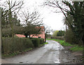
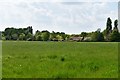
Pulham Road through the hamlet of Dickleburgh Moor
Image: © Evelyn Simak
Taken: 31 Mar 2010
0.13 miles
2
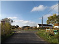
Semere Green Lane, Dickleburgh Moor
At the junction with Norwich Road
Image: © Geographer
Taken: 11 Nov 2014
0.14 miles
3
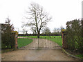
Entrance to Low Brook House
In Dickleburgh Moor.
Image: © Evelyn Simak
Taken: 31 Mar 2010
0.17 miles
4
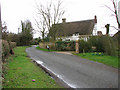
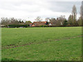
Low Brook House
The lane seen in the foreground is Pulham Road.
Image: © Evelyn Simak
Taken: 31 Mar 2010
0.18 miles
6
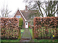
Cottage behind beech hedge in Dickleburgh Moor
Image: © Evelyn Simak
Taken: 31 Mar 2010
0.18 miles
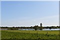
8
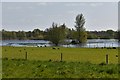
Dickleburgh Moor: Flooded drainage area
Image: © Michael Garlick
Taken: 17 Apr 2020
0.22 miles
9
Dickleburgh Moor: Flooded drainage area
Image: © Michael Garlick
Taken: 17 Apr 2020
0.24 miles