IMAGES TAKEN NEAR TO
Crown Close, DISS, IP21 4NA
Introduction
This page details the photographs taken nearby to Crown Close, IP21 4NA by members of the Geograph project.
The Geograph project started in 2005 with the aim of publishing, organising and preserving representative images for every square kilometre of Great Britain, Ireland and the Isle of Man.

There are currently over 7.5m images from over14,400 individuals and you can help contribute to the project by visiting https://www.geograph.org.uk
Image Map
Images are licensed for reuse under creativecommons.org/licenses/by-sa/2.0
Notes
- Clicking on the map will re-center to the selected point.
- The higher the marker number, the further away the image location is from the centre of the postcode.
Image Listing (142 Images Found)
Images are licensed for reuse under creativecommons.org/licenses/by-sa/2.0
Image
Details
Distance
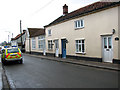
1
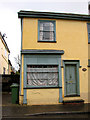
Cottage facade in The Street, Dickleburgh
Note the two running hares at the bottom left corner.
Image: © Evelyn Simak
Taken: 27 Mar 2010
0.01 miles
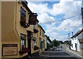
3
The Dickleburgh Crown public house in The Street
Image: © Evelyn Simak
Taken: 27 Mar 2010
0.02 miles
4
The Dickleburgh Crown public house in The Street
Image: © Evelyn Simak
Taken: 27 Mar 2010
0.03 miles
5
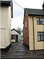
Alleyway past the Old Bakery in Dickleburgh
Image: © Evelyn Simak
Taken: 27 Mar 2010
0.03 miles
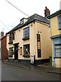
6
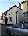
The Dickleburgh Crown Public House
Off The Street
Image: © Geographer
Taken: 4 Nov 2014
0.03 miles
7
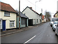
The Street past cottages in Dickleburgh
Image: © Evelyn Simak
Taken: 27 Mar 2010
0.03 miles
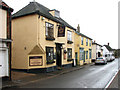
9
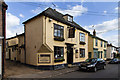
The Crown, Dickleburgh
A public house in the centre of the village.
Image: © David P Howard
Taken: 2 May 2014
0.03 miles
10
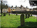
Cottages in The Street viewed across All Saints churchyard
For a view of the church see > http://www.geograph.org.uk/photo/1774146.
Image: © Evelyn Simak
Taken: 27 Mar 2010
0.04 miles