IMAGES TAKEN NEAR TO
Mill Road, DISS, IP21 4HY
Introduction
This page details the photographs taken nearby to Mill Road, IP21 4HY by members of the Geograph project.
The Geograph project started in 2005 with the aim of publishing, organising and preserving representative images for every square kilometre of Great Britain, Ireland and the Isle of Man.

There are currently over 7.5m images from over14,400 individuals and you can help contribute to the project by visiting https://www.geograph.org.uk
Image Map
Images are licensed for reuse under creativecommons.org/licenses/by-sa/2.0
Notes
- Clicking on the map will re-center to the selected point.
- The higher the marker number, the further away the image location is from the centre of the postcode.
Image Listing (17 Images Found)
Images are licensed for reuse under creativecommons.org/licenses/by-sa/2.0
Image
Details
Distance
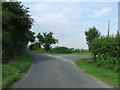
1
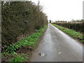
View north along Mill Road
Mill House can just be glimpsed in the distance.
Image: © Evelyn Simak
Taken: 31 Mar 2010
0.01 miles
2
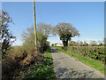
Mill Road with Mill House in the distance
Image: © Adrian S Pye
Taken: 16 Apr 2015
0.04 miles
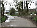
3
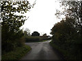
Mill Road, Thorpe Abbotts
At the junction with Back Road
Road No.C352
Image: © Geographer
Taken: 11 Nov 2014
0.05 miles
4
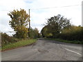
Back Road, Thorpe Abbotts
At the junction with Mill Road
Image: © Geographer
Taken: 11 Nov 2014
0.05 miles
5
Road Junction
Road junction of Mill Road and Back road near to Thorpe Abbotts, Norfolk.
Image: © Keith Evans
Taken: 9 Aug 2012
0.06 miles
6
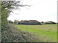
Red Barn
Used, until the roof collapsed
Image: © Adrian S Pye
Taken: 16 Apr 2015
0.13 miles
7
The approach to Mill House from Mill Road
Image: © Robert Edwards
Taken: 8 Mar 2007
0.13 miles
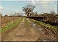
9
Driveway to Red Barn
Red Barn is situated on the eastern edge of the former Thorpe Abbotts airfield. Thorpe Abbotts airfield was built during 1942 and early 1943 for the RAF but was handed over to the Americans. The 100th Bombardment Group (Heavy) arrived in June 1943 when construction work was barely finished. The unit bombed airfields, industries, marshalling yards, and missile sites in western Europe and completed a series of attacks against Berlin in March 1944. The 100th Bomb Group Memorial Museum, dedicated to the USAAF's famous 'Bloody Hundredth' Bomb Group of WWII, is housed in the original airfield control tower near Thorpe Abbotts: http://www.100bgmus.org.uk/default.aspx
The airfield consisted of 50 hardstandings and two T-2 hangars were erected adjacent to the technical site.
See also: http://www.geograph.org.uk/article/RAF-Thorpe-Abbotts---USAAF-Station-139
Image: © Evelyn Simak
Taken: 31 Mar 2010
0.15 miles
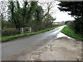
10
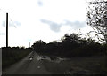
Mill Road, Thorpe Abbotts
At the field entrance
Road No.C352
Image: © Geographer
Taken: 11 Nov 2014
0.16 miles