IMAGES TAKEN NEAR TO
Thorpe Parva, DISS, IP21 4HJ
Introduction
This page details the photographs taken nearby to Thorpe Parva, IP21 4HJ by members of the Geograph project.
The Geograph project started in 2005 with the aim of publishing, organising and preserving representative images for every square kilometre of Great Britain, Ireland and the Isle of Man.

There are currently over 7.5m images from over14,400 individuals and you can help contribute to the project by visiting https://www.geograph.org.uk
Image Map
Images are licensed for reuse under creativecommons.org/licenses/by-sa/2.0
Notes
- Clicking on the map will re-center to the selected point.
- The higher the marker number, the further away the image location is from the centre of the postcode.
Image Listing (10 Images Found)
Images are licensed for reuse under creativecommons.org/licenses/by-sa/2.0
Image
Details
Distance
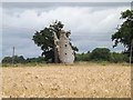
1
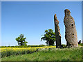
The ruined church of St Mary, Thorpe Parva
Sections of the round tower remain of the ruined church which once used to serve the since abandoned village of Thorpe Parva. The church was demolished in 1540 but the tower was left standing and used as a dove cote.
Image: © Evelyn Simak
Taken: 23 May 2010
0.19 miles
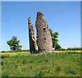
2
The ruined church of St Mary, Thorpe Parva
Sections of the round tower remain of the ruined church which once used to serve the since abandoned village of Thorpe Parva. The church was demolished in 1540 but the tower was left standing and used as a dove cote.
Image: © Evelyn Simak
Taken: 23 May 2010
0.19 miles
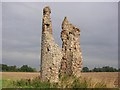
3
The ruined church of St Mary, Thorpe Parva
Sections of the round tower remain of the ruined church which once used to serve the since abandoned village of Thorpe Parva. The church was demolished in 1540 but the tower was left standing and used as a dove cote.
Image: © Evelyn Simak
Taken: 23 May 2010
0.19 miles
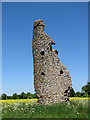
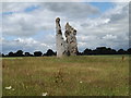
4
Ruins of Thorpe Parva church
What remains of this round tower church shows definite signs of Norman building. Probably abandoned in the reign of Elizabeth I.
Image: © Adrian S Pye
Taken: 6 Aug 2009
0.19 miles
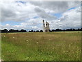
5
Remains of St.Mary's Church at Scole
Near Steeple Cottages
http://www.norfolkchurches.co.uk/thorpeparva/thorpeparva.htm
(Close up)
Image: © Geographer
Taken: 5 Jul 2016
0.20 miles
6
Remains of St.Mary's Church at Scole
Near Steeple Cottages
http://www.norfolkchurches.co.uk/thorpeparva/thorpeparva.htm
Image: © Geographer
Taken: 5 Jul 2016
0.20 miles
7
Remains of St.Mary's Church at Scole
Near Steeple Cottages
http://www.norfolkchurches.co.uk/thorpeparva/thorpeparva.htm
(Close up)
Image: © Geographer
Taken: 5 Jul 2016
0.20 miles
8
Footpath to Norwich Road & Norgate Lane
Near Steeple Cottages
Scole Footpath No.28
Image: © Geographer
Taken: 5 Jul 2016
0.20 miles
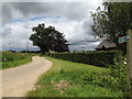
9
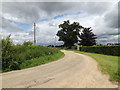
Entrance to Hall Farm Cottages & Thorpe Parva Hall
Near Steeple Cottages
Image: © Geographer
Taken: 5 Jul 2016
0.20 miles
10
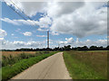
Footpath to the A143 Bungay Road
Near Steeple Cottages
Scole Footpath No.28
Image: © Geographer
Taken: 5 Jul 2016
0.21 miles