IMAGES TAKEN NEAR TO
Fellowes Close, DISS, IP21 4HE
Introduction
This page details the photographs taken nearby to Fellowes Close, IP21 4HE by members of the Geograph project.
The Geograph project started in 2005 with the aim of publishing, organising and preserving representative images for every square kilometre of Great Britain, Ireland and the Isle of Man.

There are currently over 7.5m images from over14,400 individuals and you can help contribute to the project by visiting https://www.geograph.org.uk
Image Map
Images are licensed for reuse under creativecommons.org/licenses/by-sa/2.0
Notes
- Clicking on the map will re-center to the selected point.
- The higher the marker number, the further away the image location is from the centre of the postcode.
Image Listing (147 Images Found)
Images are licensed for reuse under creativecommons.org/licenses/by-sa/2.0
Image
Details
Distance
1

St Andrew's Church, Scole, Norfolk - East window
Image: © John Salmon
Taken: 23 May 2008
0.08 miles
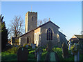
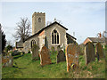
3
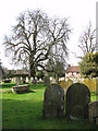
The church of St Andrew in Scole - churchyard
For a view of the church see > http://www.geograph.org.uk/photo/1766120.
Image: © Evelyn Simak
Taken: 21 Mar 2010
0.09 miles
4
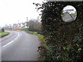
Old Bungay Road, Scole
The reflection in the broken traffic mirror (in foreground at right) shows the 16th century Manor House > http://www.geograph.org.uk/photo/2215004 - one of the oldest houses in the village, situated across the road from here.
Image: © Evelyn Simak
Taken: 31 Dec 2010
0.09 miles
6
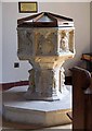
St Andrew's Church, Scole, Norfolk - Font
Image: © John Salmon
Taken: 23 May 2008
0.09 miles
7
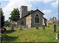
The church of St Andrew in Scole
St Andrew's church > http://www.geograph.org.uk/photo/1766120 - situated on an elevation beside the old Roman road which overlooked the crossing on the River Waveney - dates from the 13th or 14th century. The original church was built with flint and freestone. It was extended in the following centuries and a major restoration was carried out in the 19th century when the chancel floor was raised and most of the original poppy head pews removed. On Boxing Day 1962 the church was gutted by fire: roof, organ, recently installed reredos, most of the pews, the heating system and the stained glass east window were destroyed. The C15 octagonal font > http://www.geograph.org.uk/photo/1766144 is the sole medieval survivor. It was agreed to rebuild the church to its original layout with a new stained glass window and modern furnishings and the church was reconsecrated in September 1964. The stunning east window > http://www.geograph.org.uk/photo/1766154 is by Patrick Reyntienne.
Image: © Evelyn Simak
Taken: 21 Mar 2010
0.09 miles
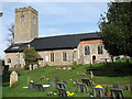
8
The church of St Andrew in Scole - south aisle
St Andrew's church > http://www.geograph.org.uk/photo/1766120 - situated on an elevation beside the old Roman road which overlooked the crossing on the River Waveney - dates from the 13th or 14th century. The original church was built with flint and freestone. It was extended in the following centuries and a major restoration was carried out in the 19th century when the chancel floor was raised and most of the original poppy head pews removed. On Boxing Day 1962 the church was gutted by fire: roof, organ, recently installed reredos, most of the pews, the heating system and the stained glass east window were destroyed. The C15 octagonal font > http://www.geograph.org.uk/photo/1766144 is the sole medieval survivor. It was agreed to rebuild the church to its original layout with a new stained glass window and modern furnishings and the church was reconsecrated in September 1964. The stunning east window > http://www.geograph.org.uk/photo/1766154 is by Patrick Reyntienne.
Image: © Evelyn Simak
Taken: 21 Mar 2010
0.09 miles
9
The church of St Andrew in Scole
St Andrew's church - situated on an elevation beside the old Roman road which overlooked the crossing on the River Waveney - dates from the 13th or 14th century. The original church was built with flint and freestone. It was extended in the following centuries and a major restoration was carried out in the 19th century when the chancel floor was raised and most of the original poppy head pews removed. On Boxing Day 1962 the church was gutted by fire: roof, organ, recently installed reredos, most of the pews, the heating system and the stained glass east window were destroyed. The C15 octagonal font > http://www.geograph.org.uk/photo/1766144 is the sole medieval survivor. It was agreed to rebuild the church to its original layout with a new stained glass window and modern furnishings and the church was reconsecrated in September 1964. The stunning east window > http://www.geograph.org.uk/photo/1766154 is by Patrick Reyntienne.
Image: © Evelyn Simak
Taken: 21 Mar 2010
0.09 miles
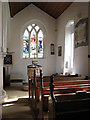
10
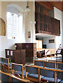
The church of St Andrew in Scole - pulpit and organ
St Andrew's church > http://www.geograph.org.uk/photo/1766120 - situated on an elevation beside the old Roman road which overlooked the crossing on the River Waveney - dates from the 13th or 14th century. The original church was built with flint and freestone. It was extended in the following centuries and a major restoration was carried out in the 19th century when the chancel floor was raised and most of the original poppy head pews removed. On Boxing Day 1962 the church was gutted by fire: roof, organ, recently installed reredos, most of the pews, the heating system and the stained glass east window were destroyed. The C15 octagonal font > http://www.geograph.org.uk/photo/1766144 is the sole medieval survivor. It was agreed to rebuild the church to its original layout with a new stained glass window and modern furnishings and the church was reconsecrated in September 1964. The stunning east window > http://www.geograph.org.uk/photo/1766154 is by Patrick Reyntienne.
Image: © Evelyn Simak
Taken: 21 Mar 2010
0.09 miles