1
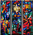
St Andrew's Church, Scole, Norfolk - East window
Image: © John Salmon
Taken: 23 May 2008
0.03 miles
2
St Andrew's Church, Scole, Norfolk - Organ
Image: © John Salmon
Taken: 23 May 2008
0.03 miles
3
St Andrew's Church, Scole, Norfolk
Image: © John Salmon
Taken: 23 May 2008
0.03 miles
4
St Andrew's Church, Scole, Norfolk - Font
Image: © John Salmon
Taken: 23 May 2008
0.03 miles
5
The church of St Andrew in Scole
St Andrew's church > http://www.geograph.org.uk/photo/1766120 - situated on an elevation beside the old Roman road which overlooked the crossing on the River Waveney - dates from the 13th or 14th century. The original church was built with flint and freestone. It was extended in the following centuries and a major restoration was carried out in the 19th century when the chancel floor was raised and most of the original poppy head pews removed. On Boxing Day 1962 the church was gutted by fire: roof, organ, recently installed reredos, most of the pews, the heating system and the stained glass east window were destroyed. The C15 octagonal font > http://www.geograph.org.uk/photo/1766144 is the sole medieval survivor. It was agreed to rebuild the church to its original layout with a new stained glass window and modern furnishings and the church was reconsecrated in September 1964. The stunning east window > http://www.geograph.org.uk/photo/1766154 is by Patrick Reyntienne.
Image: © Evelyn Simak
Taken: 21 Mar 2010
0.03 miles
6
St Andrew's Church, Scole, Norfolk
Image: © John Salmon
Taken: 23 May 2008
0.03 miles
7
St Andrew's Church, Scole, Norfolk - Porch
Image: © John Salmon
Taken: 23 May 2008
0.03 miles
8
St Andrew's Church, Scole, Norfolk - East end
Image: © John Salmon
Taken: 23 May 2008
0.03 miles
9
St Andrew's Church, Scole, Norfolk - Window south aisle
Image: © John Salmon
Taken: 23 May 2008
0.03 miles
10
The church of St Andrew in Scole - east window (detail)
Following his work at Coventry Cathedral, Patrick Reyntienne designed the church's striking new east window.
St Andrew's church > http://www.geograph.org.uk/photo/1766120 - situated on an elevation beside the old Roman road which overlooked the crossing on the River Waveney - dates from the 13th or 14th century. The original church was built with flint and freestone. It was extended in the following centuries and a major restoration was carried out in the 19th century when the chancel floor was raised and most of the original poppy head pews removed. On Boxing Day 1962 the church was gutted by fire: roof, organ, recently installed reredos, most of the pews, the heating system and the stained glass east window were destroyed. The C15 octagonal font > http://www.geograph.org.uk/photo/1766144 is the sole medieval survivor. It was agreed to rebuild the church to its original layout with a new stained glass window and modern furnishings and the church was reconsecrated in September 1964.
Image: © Evelyn Simak
Taken: 21 Mar 2010
0.04 miles


