IMAGES TAKEN NEAR TO
The Avenue, DISS, IP21 4AY
Introduction
This page details the photographs taken nearby to The Avenue, IP21 4AY by members of the Geograph project.
The Geograph project started in 2005 with the aim of publishing, organising and preserving representative images for every square kilometre of Great Britain, Ireland and the Isle of Man.

There are currently over 7.5m images from over14,400 individuals and you can help contribute to the project by visiting https://www.geograph.org.uk
Image Map
Images are licensed for reuse under creativecommons.org/licenses/by-sa/2.0
Notes
- Clicking on the map will re-center to the selected point.
- The higher the marker number, the further away the image location is from the centre of the postcode.
Image Listing (39 Images Found)
Images are licensed for reuse under creativecommons.org/licenses/by-sa/2.0
Image
Details
Distance
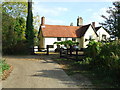
1
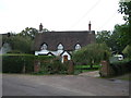
Hall Farm
Hall Farm next door to Brome Hall Brome Street, Suffolk.
Image: © Keith Evans
Taken: 18 Oct 2009
0.08 miles
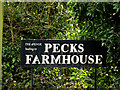
2
Pecks Farmhouse
Pecks Farmhouse Brome Street, Suffolk.
Image: © Keith Evans
Taken: 18 Oct 2009
0.08 miles
4
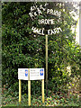
Hall Farm & Pecks Farmhouse sign
On The Avenue at the junction with Upper Oakley
Image: © Geographer
Taken: 24 Feb 2015
0.15 miles
5
Pecks Farmhouse sign
On the Avenue at the junction with Upper Oakley
Image: © Geographer
Taken: 24 Feb 2015
0.15 miles
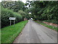
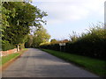
6
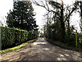
The Avenue the entrance to Pecks Farmhouse & Hall Farm
At the junction with Upper Oakley
Image: © Geographer
Taken: 24 Feb 2015
0.15 miles
7
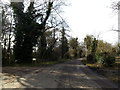
Upper Oakley, Brome Street
At the entrance to Pecks Farmhouse
Image: © Geographer
Taken: 24 Feb 2015
0.15 miles