IMAGES TAKEN NEAR TO
Kestrel Road, IPSWICH, IP2 0RP
Introduction
This page details the photographs taken nearby to Kestrel Road, IP2 0RP by members of the Geograph project.
The Geograph project started in 2005 with the aim of publishing, organising and preserving representative images for every square kilometre of Great Britain, Ireland and the Isle of Man.

There are currently over 7.5m images from over14,400 individuals and you can help contribute to the project by visiting https://www.geograph.org.uk
Image Map
Images are licensed for reuse under creativecommons.org/licenses/by-sa/2.0
Notes
- Clicking on the map will re-center to the selected point.
- The higher the marker number, the further away the image location is from the centre of the postcode.
Image Listing (16 Images Found)
Images are licensed for reuse under creativecommons.org/licenses/by-sa/2.0
Image
Details
Distance
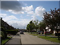
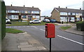
3
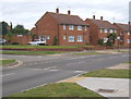
Hawthorn Drive, Chantry, at junction with Greenfinch Avenue
Large residential development of south-west Ipswich, IP2.
Image: © Andrew Hill
Taken: 18 Jul 2008
0.12 miles
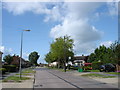
4
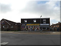
Shops on Greenfinch Avenue
At the junction with Robin Drive
Image: © Geographer
Taken: 26 Oct 2015
0.14 miles
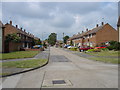
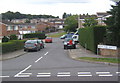
6
Holcombe Crescent, Chantry, south-west Ipswich
Looking to Bridgwater Road, IP2.
Image: © Andrew Hill
Taken: 18 Jul 2008
0.14 miles
7
Holcombe Crescent, Chantry, south-west Ipswich
Residential street viewed from the junction with Bridgwater Road, IP2.
Image: © Andrew Hill
Taken: 18 Jul 2008
0.15 miles