IMAGES TAKEN NEAR TO
Partridge Road, IPSWICH, IP2 0QJ
Introduction
This page details the photographs taken nearby to Partridge Road, IP2 0QJ by members of the Geograph project.
The Geograph project started in 2005 with the aim of publishing, organising and preserving representative images for every square kilometre of Great Britain, Ireland and the Isle of Man.

There are currently over 7.5m images from over14,400 individuals and you can help contribute to the project by visiting https://www.geograph.org.uk
Image Map
Images are licensed for reuse under creativecommons.org/licenses/by-sa/2.0
Notes
- Clicking on the map will re-center to the selected point.
- The higher the marker number, the further away the image location is from the centre of the postcode.
Image Listing (30 Images Found)
Images are licensed for reuse under creativecommons.org/licenses/by-sa/2.0
Image
Details
Distance
6
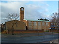
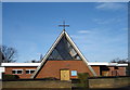
Parish Church of St. Francis
The parish church of St.Francis Chantry estate Ipswich Suffolk. For more info see http://www.suffolkchurches.co.uk/stfrancisipswich.htm
Image: © Keith Evans
Taken: 2 Jan 2007
0.14 miles
8
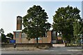
St. Francis church, Chantry
St. Francis parish church was built in 1957 to serve the rapidly expanding Chantry estate. It was designed by architect Basil Hatcher.
Image: © Simon Mortimer
Taken: 11 Sep 2020
0.15 miles
10
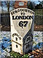
Old Milepost, London Road, Chantry Park
Metal plate attached to stone post by the A1214 (was A12), in parish of Ipswich (Ipswich District), London Road, by Avenue Lodge, Chantry Park, on the verge, North-west side of road. Turner iron plate erected by the Ipswich to Stratford St Mary Turnpike Trust in the 19th century.
Inscription reads:-
: IPSWICH / 2 / WOODBRIDGE / 9 : : SPROUGHTON / TO / LONDON / 67 : : COLCHESTER / 16 / CHELMSFORD / 38 :
Maker:-
ER & F TURNER / IPSWICH / 18(53?)
Grade II listed.
List Entry Number: 1236695 https://historicengland.org.uk/listing/the-list/list-entry/1236695
Milestone Society National ID: SU_LI67.
Image: © Milestone Society
Taken: 21 Feb 2019
0.18 miles