IMAGES TAKEN NEAR TO
Dickens Road, IPSWICH, IP2 0JW
Introduction
This page details the photographs taken nearby to Dickens Road, IP2 0JW by members of the Geograph project.
The Geograph project started in 2005 with the aim of publishing, organising and preserving representative images for every square kilometre of Great Britain, Ireland and the Isle of Man.

There are currently over 7.5m images from over14,400 individuals and you can help contribute to the project by visiting https://www.geograph.org.uk
Image Map
Images are licensed for reuse under creativecommons.org/licenses/by-sa/2.0
Notes
- Clicking on the map will re-center to the selected point.
- The higher the marker number, the further away the image location is from the centre of the postcode.
Image Listing (78 Images Found)
Images are licensed for reuse under creativecommons.org/licenses/by-sa/2.0
Image
Details
Distance
1
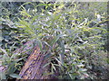
Willow logs at the Gipping Way
The logs are sprouting, Willow is good at that.
Image: © Hamish Griffin
Taken: 21 Jul 2017
0.02 miles
2
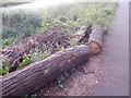
Willow logs at the Gipping Way
The logs are sprouting, Willow is good at that.
Image: © Hamish Griffin
Taken: 21 Jul 2017
0.02 miles
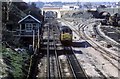
4
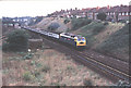
East Suffolk Junction
47584 - fittingly named County of Suffolk - passes the junction with a Norwich express. The line diverging to the left goes to Felixstowe and Lowestoft.
Image: © Martin Addison
Taken: Unknown
0.05 miles
5
East Suffolk Junction
Taken before electrification the track remodelling is seen at East Suffolk Junction during re-signalling of the area. The old signal box on the left is being done away with and all signals will then come under the control of a new signal centre at Colchester. This view is not possible today due to the overhead power wires which came with the electrification of the railway to Norwich. The old signal box was demolished not long after this picture was taken.
Image: © roger geach
Taken: 13 Apr 1984
0.05 miles
6
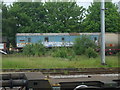
Old British railways carriage
Not sure what this is but looks like it's not cared for.
Image: © Ashley Dace
Taken: 16 May 2009
0.07 miles
7
Hadleigh Road, Ipswich
At the junction with Dunlop Road near Western House
Image: © Geographer
Taken: 31 Oct 2013
0.08 miles
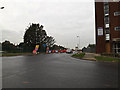
8
Dickens Road, Chantry, Ipswich
At the junction with Hadleigh Road & Pickwick Road
Image: © Geographer
Taken: 26 Oct 2015
0.08 miles
9
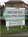
Hadleigh Road Industrial Estate & Dunlop Road signs
On Dunlop Road at the junction with Hadleigh Road near Western House
Image: © Geographer
Taken: 31 Oct 2013
0.09 miles
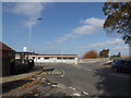
10
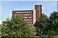
The Spectrum apartment block, Hadleigh Road
The building was formerly an office building called Western House Image, occupied by Network Rail amongst others, but has recently been converted to residential use. The view here is looking east from Harris Way.
Image: © Simon Mortimer
Taken: 12 Sep 2020
0.10 miles