IMAGES TAKEN NEAR TO
Burnthouse Lane, HARLESTON, IP20 9LN
Introduction
This page details the photographs taken nearby to Burnthouse Lane, IP20 9LN by members of the Geograph project.
The Geograph project started in 2005 with the aim of publishing, organising and preserving representative images for every square kilometre of Great Britain, Ireland and the Isle of Man.

There are currently over 7.5m images from over14,400 individuals and you can help contribute to the project by visiting https://www.geograph.org.uk
Image Map
Images are licensed for reuse under creativecommons.org/licenses/by-sa/2.0
Notes
- Clicking on the map will re-center to the selected point.
- The higher the marker number, the further away the image location is from the centre of the postcode.
Image Listing (40 Images Found)
Images are licensed for reuse under creativecommons.org/licenses/by-sa/2.0
Image
Details
Distance
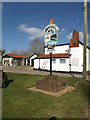
1
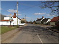
High Road & Needham Village sign
At the junction with Burnthouse Lane
Image: © Geographer
Taken: 10 Mar 2015
0.03 miles
2
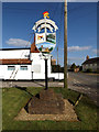
Needham Village sign
On High Road at the junction with Burnthouse Lane
Image: © Geographer
Taken: 10 Mar 2015
0.03 miles
3
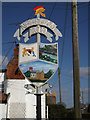
Needham Village sign
On High Road at the junction with Burnthouse Lane
(Close up)
Image: © Geographer
Taken: 10 Mar 2015
0.03 miles
4
Needham Village sign
On High Road at the junction with Burnthouse Lane
Image: © Geographer
Taken: 10 Mar 2015
0.03 miles
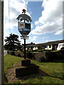
5
Needham Village sign
On High Road at the junction with Burnthouse Lane
Image: © Geographer
Taken: 10 Mar 2015
0.03 miles
6
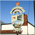
Needham village sign
Surmounted by a Roman centurions helmet giving a clue the Needham once had a small Anglo-Roman settlement. The sign bears the County of Norfolk Coat of Arms and another panel has a view of the River Waveney and some sheep grazing, Below is a view of Needham St. Peter’s church with its round tower. The sign is supported by two fish, perhaps in recognition of “The Fishmonger’s Arms” public house which once had an important role in the parish. https://www.geograph.org.uk/photo/6676703
Image: © Adrian S Pye
Taken: 15 Nov 2020
0.03 miles
7
Needham village sign and the High Road
Surmounted by a Roman centurions helmet giving a clue the Needham once had a small Anglo-Roman settlement. The sign bears the County of Norfolk Coat of Arms and another panel has a view of the River Waveney and some sheep grazing, Below is a view of Needham St. Peter’s church with its round tower. The sign is supported by two fish, perhaps in recognition of “The Fishmonger’s Arms” public house which once had an important role in the parish. https://www.geograph.org.uk/photo/6676669
Image: © Adrian S Pye
Taken: 15 Nov 2020
0.03 miles
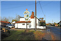
8
High Road, Needham
Near Needham Village sign
Image: © Geographer
Taken: 10 Mar 2015
0.03 miles
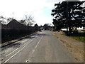
9
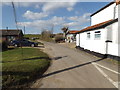
Burnthouse Lane, Needham
At the junction with High Road
Image: © Geographer
Taken: 10 Mar 2015
0.03 miles
10
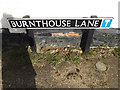
Burnthouse Lane sign
On Burnthouse Lane at the junction with High Street
Image: © Geographer
Taken: 10 Mar 2015
0.04 miles