IMAGES TAKEN NEAR TO
Needham, HARLESTON, IP20 9LE
Introduction
This page details the photographs taken nearby to IP20 9LE by members of the Geograph project.
The Geograph project started in 2005 with the aim of publishing, organising and preserving representative images for every square kilometre of Great Britain, Ireland and the Isle of Man.

There are currently over 7.5m images from over14,400 individuals and you can help contribute to the project by visiting https://www.geograph.org.uk
Image Map
Images are licensed for reuse under creativecommons.org/licenses/by-sa/2.0
Notes
- Clicking on the map will re-center to the selected point.
- The higher the marker number, the further away the image location is from the centre of the postcode.
Image Listing (38 Images Found)
Images are licensed for reuse under creativecommons.org/licenses/by-sa/2.0
Image
Details
Distance
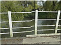
1
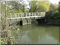
Bridge over the River Waveney at Needham old mill
The difference between the Norfolk side (left) and the Suffolk side (right) is obvious from this viewpoint.
Image: © Adrian S Pye
Taken: 28 Apr 2021
0.01 miles
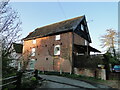
2
The former water mill at Needham
Needham Mill was built as a small 4 storey red brick building laid with Flemish bond and roofed with blue tiles, that actually stood in the parish of Weybread on the Suffolk side of the River Waveney. The mill was rebuilt after the fire of 1838 and again about 1870 after a fire destroyed the earlier timber framed weatherboarded building. Milling ceased around 1934 and the wheel and machinery were removed during the second world war and sold towards the war effort. It has been a private residence for many years.
Image: © Adrian S Pye
Taken: 28 Apr 2021
0.01 miles

5
The former water mill at Needham
Needham Mill was built as a small 4 storey red brick building laid with Flemish bond and roofed with blue tiles, that actually stood in the parish of Weybread on the Suffolk side of the River Waveney. The mill was rebuilt after the fire of 1838 and again about 1870 after a fire destroyed the earlier timber framed weatherboarded building. Milling ceased around 1934 and the wheel and machinery were removed during the second world war and sold towards the war effort. It has been a private residence for many years.
Image: © Adrian S Pye
Taken: 1 May 2021
0.01 miles
6
Tank trap left over from WWII
Under the ivy is a hairpin type tank trap; in fact there is another to the right of this one. Those which once blocked the road were removed after the threat of invasion had passed but these weren't removed as they didn't impede traffic. To see what they look like without the ivy they can be seen clearly at Narford https://www.geograph.org.uk/photo/2576491
Not listed on the Defence of Britain database.
Image: © Adrian S Pye
Taken: 28 Apr 2021
0.01 miles
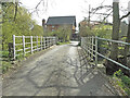
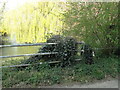
7
Where Norfolk meets Suffolk
On the bridge over the River Waveney near the former Needham watermill is this example of different standards of works. On the left is the work of the Norfolk County Council and on the right is that of the East Suffolk County Council mid way across the bridge. It would seem that Suffolk had to make adjustments to the Norfolk scheme of working. see also https://www.geograph.org.uk/photo/6822923
Image: © Adrian S Pye
Taken: 28 Apr 2021
0.01 miles
8
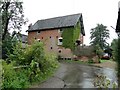
The old mill at Needham, Norfolk
The mill spans the River Waveney on the Suffolk/Norfolk border. It is now a private residence.
Image: © Adrian S Pye
Taken: 26 Aug 2010
0.01 miles
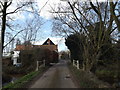
9
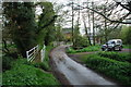
Ford at Needham Mill
This ford is found on Mill Lane just inside the border with Suffolk.
Image: © John Walton
Taken: 7 May 2012
0.02 miles
10
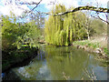
River Waveney by the Old Mill
Looking upstream.
Image: © Robin Webster
Taken: 7 Apr 2023
0.02 miles