IMAGES TAKEN NEAR TO
Skinners Lane, HARLESTON, IP20 9FH
Introduction
This page details the photographs taken nearby to Skinners Lane, IP20 9FH by members of the Geograph project.
The Geograph project started in 2005 with the aim of publishing, organising and preserving representative images for every square kilometre of Great Britain, Ireland and the Isle of Man.

There are currently over 7.5m images from over14,400 individuals and you can help contribute to the project by visiting https://www.geograph.org.uk
Image Map
Images are licensed for reuse under creativecommons.org/licenses/by-sa/2.0
Notes
- Clicking on the map will re-center to the selected point.
- The higher the marker number, the further away the image location is from the centre of the postcode.
Image Listing (2 Images Found)
Images are licensed for reuse under creativecommons.org/licenses/by-sa/2.0
Image
Details
Distance
1
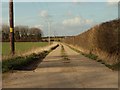
Approach to Skinner's Farm
This farm road is actually called Skinner's Lane. It lies just west of Starston.
Image: © Robert Edwards
Taken: 8 Mar 2007
0.15 miles
2
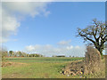
Marshall's Spinney from The Street, Starston
Overlooking a crop of Oilseed Rape
Image: © Adrian S Pye
Taken: 8 Feb 2015
0.24 miles