IMAGES TAKEN NEAR TO
Union Street, HARLESTON, IP20 9BD
Introduction
This page details the photographs taken nearby to Union Street, IP20 9BD by members of the Geograph project.
The Geograph project started in 2005 with the aim of publishing, organising and preserving representative images for every square kilometre of Great Britain, Ireland and the Isle of Man.

There are currently over 7.5m images from over14,400 individuals and you can help contribute to the project by visiting https://www.geograph.org.uk
Image Map
Images are licensed for reuse under creativecommons.org/licenses/by-sa/2.0
Notes
- Clicking on the map will re-center to the selected point.
- The higher the marker number, the further away the image location is from the centre of the postcode.
Image Listing (152 Images Found)
Images are licensed for reuse under creativecommons.org/licenses/by-sa/2.0
Image
Details
Distance
1

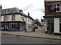
Shops between Broad Street and The Thoroughfare, Harleston
Harleston is a small market town on Norfolk's southern border, situated between Diss and Bungay. The market around which the town grew is still being held every Wednesday. Harleston has succeeded to keep its character and the streets in the town centre are full of historic buildings and traditional shops.
Image: © Evelyn Simak
Taken: 23 Aug 2010
0.00 miles
2

Shops in Broad Street, Harleston
Harleston is a small market town on Norfolk's southern border, situated between Diss and Bungay. The market around which the town grew is still being held every Wednesday. Harleston has succeeded to keep its character and the streets in the town centre are full of historic buildings and traditional shops.
Image: © Evelyn Simak
Taken: 23 Aug 2010
0.00 miles
3
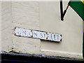
Union Street sign
On Union Street at the junction with The Thoroughfare
Image: © Geographer
Taken: 24 Mar 2015
0.01 miles
4
Union Street, Harleston
At the junction with the Thoroughfare
Image: © Geographer
Taken: 24 Mar 2015
0.01 miles
5
Shops in Broad Street, Harleston
Harleston is a small market town on Norfolk's southern border, situated between Diss and Bungay. The market around which the town grew is still being held every Wednesday. Harleston has succeeded to keep its character and the streets in the town centre are full of historic buildings and traditional shops.
Image: © Evelyn Simak
Taken: 23 Aug 2010
0.01 miles
6
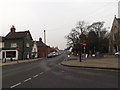
Broad Street,Harleston
At the junction with Mendham Lane & Church Street
Image: © Geographer
Taken: 17 Mar 2015
0.01 miles
7
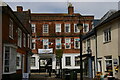
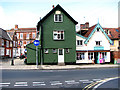
Harleston: The Swan Hotel
Two parallel one-way streets make up the centre of Harleston: The Thoroughfare and Church Street. The plan of the town suggests that these probably form the two sides of a former market place, now filled in by the narrow strip of houses between those two roads. The Swan Hotel stands on The Thoroughfare; this picture is taken from Church Street, through one of the gaps in the infill buildings.
Image: © Christopher Hilton
Taken: 24 Apr 2021
0.01 miles
8
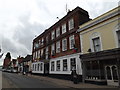
The Swan Hotel, Harleston
On the Thoroughfare at the junction with Swan Lane
Image: © Geographer
Taken: 24 Mar 2015
0.01 miles
9

Two K6 telephone boxes in Broad Street, Harleston
The telephone boxes are situated by St John the Baptist's church > http://www.geograph.org.uk/photo/2029351.
Image: © Evelyn Simak
Taken: 23 Aug 2010
0.01 miles
10
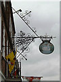
The Swan Hotel sign
On the Thoroughfare at the junction with Swan Lane
Image: © Geographer
Taken: 24 Mar 2015
0.02 miles