IMAGES TAKEN NEAR TO
Foxes Lane, HARLESTON, IP20 0PE
Introduction
This page details the photographs taken nearby to Foxes Lane, IP20 0PE by members of the Geograph project.
The Geograph project started in 2005 with the aim of publishing, organising and preserving representative images for every square kilometre of Great Britain, Ireland and the Isle of Man.

There are currently over 7.5m images from over14,400 individuals and you can help contribute to the project by visiting https://www.geograph.org.uk
Image Map
Images are licensed for reuse under creativecommons.org/licenses/by-sa/2.0
Notes
- Clicking on the map will re-center to the selected point.
- The higher the marker number, the further away the image location is from the centre of the postcode.
Image Listing (10 Images Found)
Images are licensed for reuse under creativecommons.org/licenses/by-sa/2.0
Image
Details
Distance
3
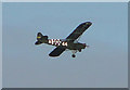
Single engine aircraft with American identification
Thanks to Spuduka it has been identified as a Taylorcraft L-2 Grasshopper.
Image: © Adrian S Pye
Taken: 14 Dec 2010
0.19 miles
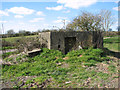
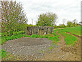
8
Pillbox off Foxes Lane
A WW2 type 22 pillbox.
Image: © Helen Steed
Taken: 11 Sep 2021
0.23 miles
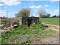
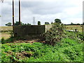
9
WWII standard type 22 pillbox
Located in remote defence of Metfield airfield
Image: © Adrian S Pye
Taken: 9 May 2021
0.23 miles
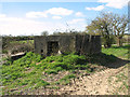
10
WWII Pill Box
WWII Pill Box on Foxes Lane guarding the entrance to Ketts farm near to Mendham Suffolk.
Image: © Keith Evans
Taken: 9 Sep 2007
0.24 miles